| ©The Archaeological Settlements of Turkey - TAY Project | ||||||
|
|
||||||
Kazane Höyük |
||||||
|
|
||||||
| Ages | Maps | Photos | ||||
| Chalcolithic EBA 14C |
 |
 |
||||
|
|
||||||
|
Type:
|
Mound | |||||
|
Altitude:
|
560 m | |||||
|
Diameter:
|
m- Direction: | |||||
|
|
||||||
|
Region:
|
Southeastern Anatolia | |||||
|
Province:
|
Sanliurfa | |||||
|
District:
|
Merkez | |||||
|
Village:
|
Konuklu | |||||
|
|
||||||
|
Destruction :
|
Contemporary Settlements | |||||
|
|
||||||
|
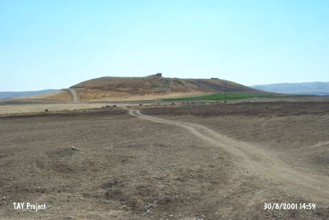
TAYEx:
|
Visited - 30/8/2001 | |||||
|
|
||||||
|
Registration State:
|
Registered For detailed registration information please refer to Turkish pages. | |||||
 |
||||||
| Location: It lies 5 km southeast of the Sanliurfa Province. It is called Kazan Tepe; located 600 m south of the Kazane Village; recently named Konuklu. |
| Geography and Environment: It is one of the biggest settlements in this region; having an extraordinary dimension of ca. 1000x1200 m including both the lower city and the outer city. Inhabitants of this site probably chose it for settling because it is located at the mountain entrance between Northern Mesopotamia and Southeastern Anatolia and in a narrow valley where the trade road runs through. It has been surrounded by a fertile land. It is suggested that the culture of Northern Mesopotamia attained its summit in this region. On the basis of the distribution of pottery; excavation team claims that an area of 40 ha. was settled during the midst and second half of the third millennium BC [Wattenmaker 1997:83]. |
| Destruction Details: There is a water reservoir on top hill and the excavated area is being used for agricultural activities [TAYEx 30.8.2001]. |