|
©The Archaeological Settlements of Turkey - TAY Project
|
|
|
|
|
|
Kazane Höyük |
|
|
For site maps and drawings please click on the picture... 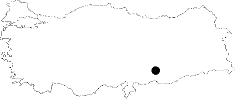 |
For photographs please click on the photo... 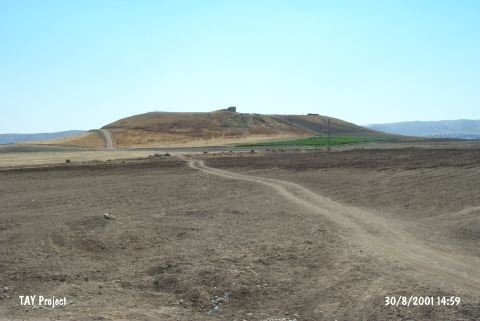 |
|
Type:
|
Mound |
|
Altitude:
|
560 m |
|
Region:
|
Southeastern Anatolia |
|
Province:
|
Sanliurfa |
|
District:
|
Merkez |
|
Village:
|
Konuklu |
|
Investigation Method:
|
Excavation |
|
Period:
|
EBA III |
|
|
|
 |
|
| Location: It lies 5 km southeast of the Sanliurfa Province. It is called Kazan Tepe; located 600 m south of the Kazane Village; recently named Konuklu. |
| Geography and Environment: It is one of the biggest settlements in this region; having an extraordinary dimension of ca. 1000x1200 m including both the lower city and the outer city. Inhabitants of this site probably chose it for settling because it is located at the mountain entrance between Northern Mesopotamia and Southeastern Anatolia and in a narrow valley where the trade road runs through. It has been surrounded by a fertile land. It is suggested that the culture of Northern Mesopotamia attained its summit in this region. On the basis of the distribution of pottery; excavation team claims that an area of 40 ha. was settled during the midst and second half of the third millennium BC [Wattenmaker 1997:83]. |
| History: |
| Research and Excavation: Before starting the excavations; the excavation team carried out a systematic survey and determined the territory of the settlement and the periods it was inhabited depending on the distribution of pottery. One of the reasons why the excavations were started; under P. Wattenmaker of Virginia University; USA; is that the main irrigation channel built for GAP project passes by the lower town of the mound in the south and east and that the irrigation system connected to this channel would have threaten the lower city and some parts of the outer city. Three trenches were opened to verify the stratification of the mound and its surrounding territory; a stepped trench (Area H) aiming to locate particularly the settlements of the fourth millennium BC on the west; a trench at the "Lower City" (Area C) on the east and a trench at the "Outer City" (Area F) on the south. Early Halaf and Halaf layers were studied by R. Bernbeck; S. Pollock and C. Coursey during 1996-1998. It takes place in the registered archaeological sites list prepared by Ministry of Culture and Tourism. |
| Stratigraphy: Both excavation and surface finds revealed that the Kazane Höyük and its surrounding territory had been occupied during the Late Neolithic Age; the Halaf Period; the Late Chalcolithic Age; the EBA and MBA; the most significant one being the settlements of EBA II and III. Presence of a MBA settlement is only based on the pottery finds. |
| Small Finds: Architecture: The richest architectural finds of Kazane Höyük belong to EBA II and III when the settlement was greatly enlarged compared to EBA I period. Settlement of this period was not excavated in detail; but excavation conducted in the Lower City in Area C yielded a mudbrick construction ringed with monumental fortification walls with outer stone foundations. Length of the exterior (?) wall extending in the east-west direction exceeds 50 m. Only 18 m of the wall extending in the north-south direction came to light. It is estimated to measure 900 square meters; for the present. As a part of the construction technique; big stones were used in the interior and exterior surfaces whereas smaller stones in between. The stones were attached by loam mortar. Foundation is 1 m thick; in three lines where the superstructure is built of neatly moulded mud-bricks. Thin; corridor-like structure which might be considered as an entrance or a passageway measures 13 m in length. In a mudbrick construction located to the north of this structure towards the center of the settlement; two building levels were observed. Upper level has been damaged due to deep ploughing while the lower level yields better finds. In both of them; the mudbrick walls are plastered. It is observed that uncovered rooms have passages in between. The eastern room yielded large amount of ashes; coals and carbonized grains. The deposit of this room is thicker than the others. Excavation conducted in Area F; i.e. in the Outer City where workshops might be located yielded the section of a structure with stone foundations. It is suggested to be contemporary with the upper production phase of Lower Town. Depending on the finds; it is also suggested that this site was; probably; a weaving atelier. Pottery: Sherds of vessels with bordered lips typical of EBA I recovered in this region; prove; at least the presence of EBA I. The Lower City excavations of Kazane Höyük yielded samples of all pottery and sherds recovered from the other settlements dated to EBA II in this region. Sherds of wares like simple plain ware; horizontally reserved slip washed ware; metallic/stone ware; band/strip painting decorated ware and mottled ware were collected. Exposure of decorated wares with a high percentage of 30 % is an interesting find of this industry. It is suggested that pottery of the painting decorated ware was; probably; produced by the potters of the settlement. Small Finds: Samples of flake stone industry; rough stone tools; bone awls; terra cotta discs; bronze pins; copper needles are very rare. The excavation of the Outer City yielded two pedestals; a seal impressed storage jar; some tools of chipped stone; a sickle/blade and an animal figurine made of clay. Fauna: Inside the structure uncovered during the excavation of the Outer City; sheep; goat and cow bones were recovered. |
| Remains: |
| Interpretation and Dating: The EBA settlement of Kazane Höyük holds the distinctiveness of being the biggest settlement in Southeastern Anatolia with its occupied area of 40 ha. for the time being according to the excavation leader. However; surveys conducted in the region; generally; concentrate on the uphill without taking the Lower/Down City and Outer City (outer settlement) into consideration. And; it is usually cited as if the settlement consists of only the conic hill. Therefore; it might be misleading to propose that Kazane is the biggest settlement in the region. A comparison with Titris Höyük located nearby is necessary for the EBA settlement. Elaborate works and monumental status of the structures in the excavated areas lead us to consider that we are dealing with a settlement bearing urban characteristics. Its economy has a division of labor. It can be suggested that the leader of the city; probably; lived in the uphill or the inner castle near the uphill. Continuation of Kazane Höyük excavations will enlighten the most significant settlement in the vicinity of Sanliurfa. |