| ©The Archaeological Settlements of Turkey - TAY Project | ||||||
|
|
||||||
Kabarsa |
||||||
|
|
||||||
| Ages | Maps | Photos | ||||
| Neolithic EBA |
 |
 |
||||
|
|
||||||
|
Type:
|
Mound | |||||
|
Altitude:
|
130 m | |||||
|
Diameter:
|
m- Direction: | |||||
|
|
||||||
|
Region:
|
Mediterranean | |||||
|
Province:
|
Mersin | |||||
|
District:
|
Tarsus | |||||
|
Village:
|
Mahmutaga | |||||
|
|
||||||
|
Destruction :
|
Agriculture - Contemporary Settlements - Attention | |||||
|
|
||||||
|
TAYEx:
|
Visited - 15/7/2001 | |||||
|
|
||||||
|
Registration State:
|
Registered For detailed registration information please refer to Turkish pages. | |||||
 |
||||||
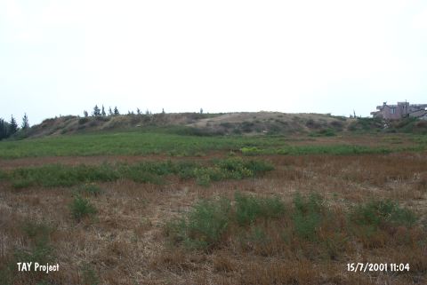
| Location: This site lies in Mahmutaga Village; south of the Tarsus-Adana highway; 7 km east of the town of Tarsus; northeast of the city of Mersin. |
| Geography and Environment: The mound is 10-12 m high. |
| Destruction Details: The mound has been damaged due to agricultural activities and illicit diggings. It has been bisected. There are houses on its southern slope and its skirts are being cultivated. The eastern part is afforested [TAYEx 15.7.2001]. |