| ©The Archaeological Settlements of Turkey - TAY Project | ||||||
|
|
||||||
Alacahöyük |
||||||
|
|
||||||
| Ages | Maps | Photos | ||||
| Chalcolithic EBA IA 14C |
 |
 |
||||
|
|
||||||
|
Type:
|
Mound | |||||
|
Altitude:
|
1000 m | |||||
|
Diameter:
|
m- Direction: | |||||
|
|
||||||
|
Region:
|
Central Anatolia | |||||
|
Province:
|
Çorum | |||||
|
District:
|
Alaca | |||||
|
Village:
|
Höyük | |||||
|
|
||||||
|
|
||||||
|
|
||||||
|
TAYEx:
|
Visited - 15/8/2003 | |||||
|
|
||||||
|
Registration State:
|
Registered For detailed registration information please refer to Turkish pages. | |||||
 |
||||||
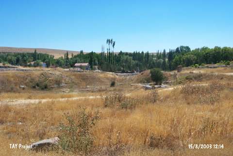
| Location: The site lies south of the city of Çorum; west-northwest of the Alaca District. |
| Geography and Environment: Höyük Village has been moved away from the site for touristic purposes. The 13-15 m high; ovoid mound measures 310x275 m. The mound appears to have two cones due to its south and northeast elevations and the defile between these elevations. There is the grave of a saint on the southern elevation. Fresh water springs; called Çigdemlik; lie close to the mound. The surroundıng fertile lands of the mound are located in the valley irrigated by the Horam Özü Stream that joins with Budaközü around Sungurlu and empties into Halys. Although it has no connection with the Alaca District; the site was named Alaca as the only road that went to Höyük Village passed from the Alaca District in 1930-35. This name continues to be used. |
| Destruction Details: |