|
©The Archaeological Settlements of Turkey - TAY Project
|
|
|
|
|
|
Alacahöyük |
|
|
For site maps and drawings please click on the picture...  |
For photographs please click on the photo... 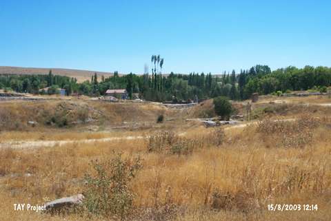 |
|
Type:
|
Mound |
|
Altitude:
|
1000 m |
|
Region:
|
Central Anatolia |
|
Province:
|
Çorum |
|
District:
|
Alaca |
|
Village:
|
Höyük |
|
Investigation Method:
|
Excavation |
|
Period:
|
Late |
|
|
|
 |
|
| Location: The site lies south of the city of Çorum; west-northwest of the Alaca District. |
| Geography and Environment: Höyük Village has been moved away from the site for touristic purposes. The 13-15 m high; ovoid mound measures 310x275 m. The mound appears to have two cones due to its south and northeast elevations and the defile between these elevations. There is the grave of a saint on the southern elevation. Fresh water springs; called Çigdemlik; lie close to the mound. The surroundıng fertile lands of the mound are located in the valley irrigated by the Horam Özü Stream that joins with Budaközü around Sungurlu and empties into Halys. Although it has no connection with the Alaca District; the site was named Alaca as the only road that went to Höyük Village passed from the Alaca District in 1930-35. This name continues to be used. |
| History: |
| Research and Excavation: Alacahöyük became famous from its sphinxes with the help of W.G. Hamilton in 1835; and was visited by many researchers and travellers afterwards. G. Perrot made a plan of the door with the Sphinx Gate in 1861. Chantre (1894); Wincler and Makridi Bey (1907) made small soundings around this door. H.H. von der Osten brought attention to the mound with his maps and drawings. Excavations were conducted by R.O. Arik in 1935 with the encouragements of Atatürk; and were taken over by H.Z. Kosay in 1936. Many excavations were conducted until 1970. The buildings; from the Hittite and Phrygian Period; were restored by M. Akok. Although the scientific excavations began again in 1994; there is nothing published about the Chalcolithic Age levels yet. It takes place in the registered archaeological sites list prepared by Ministry of Culture and Tourism. |
| Stratigraphy: Compared to the other excavations conducted by Turkish teams; the excavations at this site lasted rather long and the archaeological work was published well. 4 levels were recovered from the surface down to the virgin soil as follows [Kosay 1938:151]: Level I / 1st building level: Phrygian Period Level II / 2-4. building levels: Hittite Period Level III / 5-8. building levels: EBA Level IV / 9-12. building levels: Chalcolithic Age Virgin Soil A small amount of pottery indicating a meager Ottoman-Byzantine settlement; as well as a Phrygian settlement; were found in first level. The Chalcolithic Age building levels begin at 9.80 m of depth. Virgin soil was reached after 13.81 m. It is possible to observe that the Chalcolithic Age levels rise at the centre of the mound in the drawing of the main section by Kosay. However; no detailed information is given. The Chalcolithic levels were numbered as 9-14 in the first excavation in 1935 [Arik 1937b]. Parzinger [Parzinger 1993a:pl.9] and Orthmann [Orthmann 1963] also make use of this stratigraphical numbering. |
| Small Finds: Architecture: A plan of the Chalcolithic settlement (s) cannot be drawn for now; because the excavators could only reach Chalcolithic building levels at a few places. However; it is possible to understand the construction technology by studying some recovered buildings. Kosay does not give any information about the plans of these buildings; which were published with the drawings of M. Akok. The plans and the three dimensional drawings of M. Akok suggest plastered walls built up with small and large thin mud-bricks positioned one after another; over stone foundation or floorment walls. Although there is no data about the roof mesh; the buildings are thought to have flat roofs like the modern mud brick architecture of Anatolian villages. The wooden crossbeams and reeds below the thin cover of soil on the roof is also similar. The building floors are plastered with clay. There are adjacent rectangular rooms and hearths in the houses. Mud plastered reed walls are reported in the 1963-67 research of Alaca [Kosay-Akok 1973:XII]. There is no information about the subject in the following publications. Therefore; it is not known whether these walls belong to the wattle-and-daub huts or not. During the 2012 studies, a second fire layer was encountered under the fill with a thickness of 53 cm, which is located under the mud brick rubble in Trench H4 19. This fire layer yielded a high density of LAte Chalcolithic potsherds. However, it is not yet possible to relate these sherds to any building level [Çinaroglu et al. 2014]. Ceramics: Sherds of similar ware groups were recovered form the Chalcolithic Age building levels. The assemblages from different building levels show no difference. Sherds of heavy sand-tempered paint slipped burnished black ware; medium-coarse pasted brown ware; exterior grey-black and black interior ware; burnished fine ware with exterior black and yellow-brown interior; were recovered. Burnished ware with exterior grey surface colors and interior black was found in the lowest building levels of the Chalcolithic Age. The variety of forms is limited. There is the presence of characteristical forms of Central Anatolia such as cylindirical bowls with flat floors and open mouths; fruit-stands with high pedestals; jars; and one or two-handled juglets with one or two handles. In addition; sherds in burnished ware with red mottled interior and black exterior with red bands; were rarely recovered. The handles recovered from these building levels of Alaca vary: schematic animals; knobbed handles; loop handles. Some ware groups are excised; incised and relief decorated. Chevrons; parallel lines; wavy-lines; and pointille decorations are common. Clay: Weight hangers; ring; rattle; spindle-whorl; and a few figurines were recovered. Chipped Stone: The use of flintstone is more common than the use of obsidian. Blade industry is dominant. There are pieces that hint the use of half transparent obsidian as a raw material. Triangular arrowheads made of flintstone provide information about the daily life of the people. Ground Stone: The Chalcolithic Age communities of Alacahöyük used stone axes with a shaft hole as well as flat axes in their daily lives. Grinding stones make up the rest of the coarse tool group. Bone / Antler: Numerous awls were recovered besides bone hammers; handles; chert sickles. The function of bone hammers; which were also found in the EBA levels; is not known. Human Remains: The Chalcolithic Age burial traditions of Alacahöyük are only published as drawings. Burials were in hocker position with grave goods. Apart from pots; there are copper bracelets. Cist graves and inhumation are examples of grave types of Alacahöyük. There are double burials as well as single burials [Kosay-Akok 1966;pl.146]. |
| Remains: |
| Interpretation and Dating: Alacahöyük is one of the earliest excavations in the history of Turkish archaeology. There are no carbon-14 results of the Chalcolithic Age building levels. However; there are some resemblances beyween the finds of Alacahöyük and the culture of the Late Chalcolithic Age in Büyük Güllücek and Pazarli. According to Yakar; these building levels date to the Late Chalcolithic Age-EBA; the end of the 4th Millennium BC. Although Parzinger thinks that the 9-14 Phases are contemporary with Karanovo VI; he states the beginning of the 9-14 Phases as Karanovo III [Parzinger 1993a:lev.9]. The photographs used in the publications suggest that the building levels; which were declared as 9-12 by Kosay; contained different types of wares. Due to this; the Chalcolithic Age occupational phases of Alacahöyük; its finds; and their absolute datings remain argumantative. It is hoped that the new excavations started in 1994 will find solutions to these problems. |