| ©The Archaeological Settlements of Turkey - TAY Project | ||||||
|
|
||||||
Gözlükule |
||||||
|
|
||||||
| Ages | Maps | Photos | ||||
| Neolithic Chalcolithic EBA IA |
 |
 |
||||
|
|
||||||
|
Type:
|
Mound | |||||
|
Altitude:
|
150 m | |||||
|
Diameter:
|
m- Direction: | |||||
|
|
||||||
|
Region:
|
Mediterranean | |||||
|
Province:
|
Mersin | |||||
|
District:
|
Tarsus | |||||
|
Village:
|
Merkez | |||||
|
|
||||||
|
Destruction :
|
Contemporary Settlements | |||||
|
|
||||||
|
TAYEx:
|
Visited - 14/7/2001 | |||||
|
|
||||||
|
Registration State:
|
Registered For detailed registration information please refer to Turkish pages. | |||||
 |
||||||
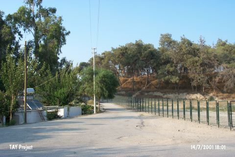
| Location: The site lies in Gözlükule Quarter; southwest of Tarsus District northeast of Içel Province. The mound is known as "Tarsus" in some archaeological publications. |
| Geography and Environment: Flat and conical mound is 25 m long; and has a diameter of 300 m. Modern settlements surround the site; today. Tarsus Stream passes by the eastern side. The settlement is thought to be located very close to the sea during the first settlement. |
| Destruction Details: The southern part of the mound has been cut by the road and there is small part left in the middle of the road that points its relation with the antique city. It is being used as a park of the district in the present time [TAYEx 14.7.2001]. |