|
|
||||
|
|
||||
|
Yaglik / Yaglak |
||||
|
For cave maps and drawings please click on the picture... |
For photographs please click on the photo... |
|||
|
 |
|||
|
Type: |
Cave | |||
|
Altitude: |
1000 m | |||
|
Depth: |
m | |||
|
Length: |
m | |||
|
Region: |
Mediterranean | |||
|
Province: |
Kahramanmaras | |||
|
District: |
Merkez | |||
|
Village: |
Döngel | |||
|
|
||||
 |
||||
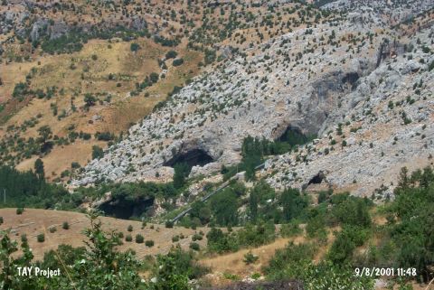
| Location: This cave-site lies 38 km northwest of Kahramanmaras; east of the village of Döngel. One can reach the mound by a climbing of 800 m from the village. |
| Structural Properties and formation : The cave is located in an area full of deep valleys and high rocky hills. It has a rather mellow climate in winter compared to the nearby locations due to the mountains surrounding the northern front. The entrance faces south. It is a midsize cave. |
| Research History: It was first visited by Kökten in 1959. Kökten has opened a 3x4 m test trench in the cave; without providing any further information about the location. |
| Findings: As a result of the excavation; Kökten found loose; black dirt containing clay and fertilizer at a 110 cm depth. The findings of this layer are mixed. according to Kökten; another layer of 100 cm thick under the first one houses potsherds probably dating to the Neolithic era. In the third layer at the bottom with a thickness of 66 cm; the potsherds disappear; and instead; there are typical microlith tools of the Aurignacien era made of silex. |