| ©The Archaeological Settlements of Turkey - TAY Project | ||||||
|
|
||||||
Yaglik / Yaglak |
||||||
|
|
||||||
| Ages | Maps | Photos | ||||
| Palaeolithic/Epipalaeolithic Neolithic EBA |
 |
 |
||||
|
|
||||||
|
Type:
|
Cave | |||||
|
Altitude:
|
1000 m | |||||
|
Diameter:
|
m- Direction: | |||||
|
|
||||||
|
Region:
|
Mediterranean | |||||
|
Province:
|
Kahramanmaras | |||||
|
District:
|
Merkez | |||||
|
Village:
|
Döngel | |||||
|
|
||||||
|
Destruction :
|
Highways, roads, bridges etc. | |||||
|
|
||||||
|
TAYEx:
|
Visited - 9/8/2001 | |||||
|
|
||||||
|
Registration State:
|
For detailed registration information please refer to Turkish pages. | |||||
 |
||||||
| Location: This cave-site lies 38 km northwest of Kahramanmaras; east of the village of Döngel. One can reach the mound by a climbing of 800 m from the village. |
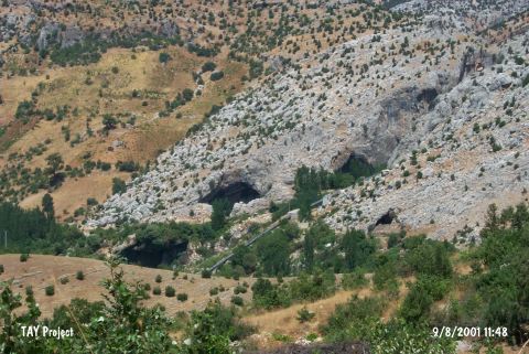
| Geography and Environment: The Keleblik (Güvercinlik); Develik; Örülü; Direkli; Orta; Yassikarinca; Tütünlü; Isli caves in and around the Yaglik Cave; lie in steep cliffs overlooking the deep valleys. The surrounding region is karstic. The mouth of the cave faces south and measures 10x5 m. In some publications the local name of the cave is Yaglik while in others it is Yaglak. |
| Destruction Details: |