| ©The Archaeological Settlements of Turkey - TAY Project | ||||||
|
|
||||||
Eskiyapar |
||||||
|
|
||||||
| Ages | Maps | Photos | ||||
| EBA IA 14C |
 |
 |
||||
|
|
||||||
|
Type:
|
Mound | |||||
|
Altitude:
|
870 m | |||||
|
Diameter:
|
m- Direction: | |||||
|
|
||||||
|
Region:
|
Black Sea | |||||
|
Province:
|
Çorum | |||||
|
District:
|
Alaca | |||||
|
Village:
|
Eskiyapar | |||||
|
|
||||||
|
|
||||||
|
|
||||||
|
TAYEx:
|
Visited - 15/8/2003 | |||||
|
|
||||||
|
Registration State:
|
For detailed registration information please refer to Turkish pages. | |||||
 |
||||||
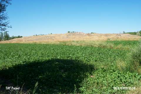
| Location: It is located in the village of Eskiyapar; 6 km west of Alaca District; south of the Çorum Province. The modern village was moved away in 1983-84 and the surface of the mound was cleared. |
| Geography and Environment: It is one of the biggest mounds in the vicinity. It measures 13 m in height and 350 m in diameter. It is surrounded by a watery land in the Hüseyinabad Plain. During the studies restarted in 2010, it was measured as 11-14 m in high, 280 m in diameter on the south-east direction, 320 m in diameter on the north-west direction and the elevation of its highest is 960 m [Sipahi 2012:515]. Eskiyapar Höyük was surrounded by the major centers of Hittites such as Alaca Höyük, Bogazköy, Ortaköy. Therefore the settlement functioned as a crossroad between three settlements and constituted a geographical integrity Sipahi 2012:1]. |
| Destruction Details: |