|
©The Archaeological Settlements of Turkey - TAY Project
|
|
|
|
|
|
Eskiyapar |
|
|
For site maps and drawings please click on the picture...  |
For photographs please click on the photo... 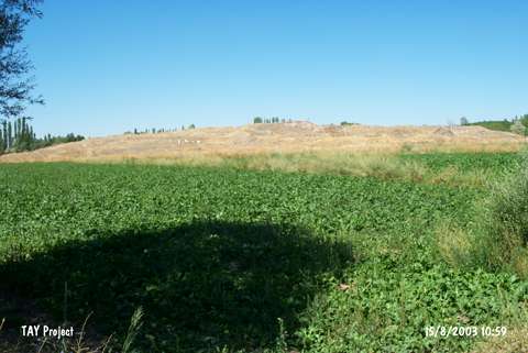 |
|
Type:
|
Mound |
|
Altitude:
|
870 m |
|
Region:
|
Black Sea |
|
Province:
|
Çorum |
|
District:
|
Alaca |
|
Village:
|
Eskiyapar |
|
Investigation Method:
|
Excavation |
|
Period:
|
Early Phrygian Middle Phrygian Late Phrygian |
|
|
|
 |
|
| Location: It is located in the village of Eskiyapar; 6 km west of Alaca District; south of the Çorum Province. The modern village was moved away in 1983-84 and the surface of the mound was cleared. |
| Geography and Environment: It is one of the biggest mounds in the vicinity. It measures 13 m in height and 350 m in diameter. It is surrounded by a watery land in the Hüseyinabad Plain. During the studies restarted in 2010, it was measured as 11-14 m in high, 280 m in diameter on the south-east direction, 320 m in diameter on the north-west direction and the elevation of its highest is 960 m [Sipahi 2012:515]. Eskiyapar Höyük was surrounded by the major centers of Hittites such as Alaca Höyük, Bogazköy, Ortaköy. Therefore the settlement functioned as a crossroad between three settlements and constituted a geographical integrity Sipahi 2012:1]. |
| History: |
| Research and Excavation: Research and Excavation: One of the first researches who mentioned Eskiyapar in the first half of 19th century was W.J. Hamilton. H.H. Von der Osten named Eskiyapar as Altiyapan. Also J.G.C. Anderson mentioned Eskiyapar in his study in 1903. He told two millstones were taken formerly from the village and localized Eskiyapar as ancient Karissa. J. Garstang cited this landscape in his paper [Sipahi 2012:515]. It was first excavated by E. Akurgal in 1945 as a sounding followed by R. Temizer; director of the Anatolian Civilizations Museum from 1968 to 1982. It was re-excavated under I. Ediz in the name of the Museum of Çorum in 1991-1992 [Ediz 1994:109]. In 1991-1992 on behalf of Çorum Museum, I.Ediz directed an excavation on the north part of the mound [Ediz 1994:109]. The EBA levels were not reached during the last excavation. The new term researches were started in 2010 under the directorship of T.Sipahi. |
| Stratigraphy: The sounding study which was held by E.Akurgal emphasized that Eskiyapar involved the cultures represented in Pazarlı and Alacahöyük [Sipahi 2012:515]. A total four layers dating to the Byzantine, Roman, Galatian, Phrygian Periods and Middle and Late Bronze Ages were identified. It appears that the largest occupation was during the Hittite Empire and Old Hittite Periods. The underlying building levels 5 and 6 are dated to the Early Bronze Age. The excavations which were restarted in 2010, researchers reached lower layers under Çorum Museum's excavation degree and 6 architectural levels had been identified. The last Hittite architectural level was revealed close to the surface. The architectural layers above identified culture levels of Hittite, are frequently Late and Middle Hittite. Middle Hittite layer was destroyed by Bronze Age. The highest layer, remains of a Roman grave and very few traces of Hellenistic pavements and floors were recovered [Sipahi 2012: 517]. According to 2010 results in A trench, it has emerged that Hittite residential layers were intensified at north section, in IA the mound were smaller, Phrygian settlement were observed largely at south, west and east sections and above them there were Hellenistic and subsequent cultures. After all these stages, Eskiyapar had reached its current condition [Sipahi 2012:518]. |
| Small Finds: Architectural Remains: The mixed soil with no cultural layers due to destruction of the mound yielded some walls with an uncertain plan, dating to the Late Phrygian and Early Hellenistic Periods. Some Phrygian walls with two phases were exposed in the grid square 0/6. The excavations restarted in 2010, researchers descended to lower layers which were under the Çorum Museum's excavation degree and named this level as Trench 'A' [Sipahi 2012:518]. In 2011, south section of Trench A was extended and at west section remains of a large building with stone pavements were found. The building was dated to Middle Hittite. These layer 2 buildings were destructed by Frig constructions [Sipahi 2012: 3-4]. The 2013 studies concentrated on the eastern section of Trench A. Trench A was enlarged towards the east and this new trench was named Trench B. The studies show that the Phrygian occupation concentrated in this area. The remnants belonging to this period have severely damaged Structure A of Middle Hittite. The Phrygian remains, on the other hand, have been damaged by contemporary village houses. However, remains of foundation belonging to Phrygian structures could be identified in some spots. Three building levels of IA were determined in this section [http://www.ttk.gov.tr/templates/resimler/File/Kazilar/2013/14-2013_Eskiyapar.pdf, 2.7.2016, 16:21]. Pottery: In 2010, during the cleaning studies before excavation, a mixed Hittite, Phrygian and Roman material was recovered [Sipahi 2012: 519]. During the 2013 studies, a baked clay ryton, cult vase and trefoil-jug belonging to Phrygian Period were found [http://www.ttk.gov.tr/templates/resimler/File/Kazilar/2013/14-2013_Eskiyapar.pdf, 2.7.2016, 16:21]. |
| Remains: |
| Interpretation and Dating: |