| ©The Archaeological Settlements of Turkey - TAY Project | ||||||
|
|
||||||
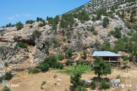
Direkli Magarasi |
||||||
|
|
||||||
| Ages | Maps | Photos | ||||
| Palaeolithic/Epipalaeolithic Neolithic EBA |
 |
 |
||||
|
|
||||||
|
Type:
|
Cave | |||||
|
Altitude:
|
1130 m | |||||
|
Diameter:
|
m- Direction: | |||||
|
|
||||||
|
Region:
|
Mediterranean | |||||
|
Province:
|
Kahramanmaras | |||||
|
District:
|
Merkez | |||||
|
Village:
|
Döngel | |||||
|
|
||||||
|
|
||||||
|
|
||||||
|
TAYEx:
|
Visited - 9/8/2001 | |||||
|
|
||||||
|
Registration State:
|
For detailed registration information please refer to Turkish pages. | |||||
 |
||||||
| Location: This cave-site lies east of the former settlement of Döngel Village and west of the new one which is 38 km; as the crow flies; northwest of the city of Kahramanmaras. |
| Geography and Environment: The presence of many caves in the vicinity suggests that it is a karstic region (for more information on the caves in this area; see the site of Yaglik in this volume). Direkli Cave faces south and Tekir Stream flows west of the cave. There must be nearby springs. |
| Destruction Details: |