| ©The Archaeological Settlements of Turkey - TAY Project | ||||||
|
|
||||||
Sariket Mezarligi |
||||||
|
|
||||||
| Ages | Maps | Photos | ||||
| EBA |
 |
 |
||||
|
|
||||||
|
Type:
|
Cemetery | |||||
|
Altitude:
|
855 m | |||||
|
Diameter:
|
m- Direction: | |||||
|
|
||||||
|
Region:
|
Marmara | |||||
|
Province:
|
Bilecik | |||||
|
District:
|
Sögüt | |||||
|
Village:
|
Zemzemiye | |||||
|
|
||||||
|
Destruction :
|
Contemporary Settlements | |||||
|
|
||||||
|
TAYEx:
|
Visited - 29/6/2002 | |||||
|
|
||||||
|
Registration State:
|
Registered For detailed registration information please refer to Turkish pages. | |||||
 |
||||||
| Location: It lies immediate west of the exit to Sögüt; north of the Bursa-Istanbul highway; south of the Zemzemiye Village; about 25 km west of Eskisehir on the border of the Bilecik-Eskisehir Provinces. The cemetery called Sariket is located 1.2 km south of the site of Demircihöyük. |
| Geography and Environment: Demircihöyük is a small hill; ca. 5 m high above the plain level. The western side has been eroded by a stream passing by; located on the edge of a small plain irrigated by the Sansu Stream in a transition point to the coastal Marmara. The Sariket cemetery has been severely damaged by the pits of natural gas piping; besides deep ploughing. Since the plain was filled up for thousands of years due to erosion; the remains of the first inhabitants of Demirci Mevkii were brought to light only after 7-8 m below the plain level. The water table at 4-6 m depth made it harder to excavate the lower levels. Exposure of pottery dating from the Neolithic and Chalcolithic Ages inside the mudbrick walls of EBA structures led the excavator to suggest the presence of a mound belonging to these ages. For removal of clay earth; probably an earlier mound was preferred and remaining of this mound was locked under an alluvium deposit. The cultural deposit is ca. 12 m thick. The mound is presumed to be located on a trade road between the Anatolian Plateau and the Sakarya River or the Marmara Depression. The modern highway simulating the same route supports this thesis. |
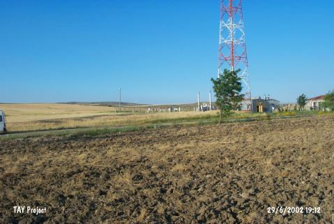
| Destruction Details: There is wet gas station and Botas link line on the site [TAYEx 29.6.2002]. |