| ©The Archaeological Settlements of Turkey - TAY Project | ||||||
|
|
||||||
Çukurkent |
||||||
|
|
||||||
| Ages | Maps | Photos | ||||
| Neolithic Greek-Roman |
 |
 |
||||
|
|
||||||
|
Type:
|
Flat Settlement | |||||
|
Altitude:
|
1130 m | |||||
|
Diameter:
|
m- Direction: | |||||
|
|
||||||
|
Region:
|
Mediterranean | |||||
|
Province:
|
Konya | |||||
|
District:
|
Hüyük | |||||
|
Village:
|
Çukurkent | |||||
|
|
||||||
|
Destruction :
|
Agriculture | |||||
|
|
||||||
|
TAYEx:
|
Visited - 11/7/2001 | |||||
|
|
||||||
|
Registration State:
|
Registered For detailed registration information please refer to Turkish pages. | |||||
 |
||||||
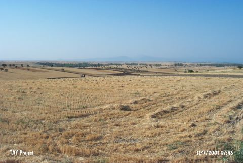
| Location: The site of Çukurkent lies close to the Beysehir-Sarkikaraagaç highway; 28-29 km northwest of the town of Beysehir; west of the city of Konya. It locates on a field in Bozyer Mevkii; 1 km away from Çukurkent Village; between the villages of Kireli and Yeniköy. |
| Geography and Environment: The information provided on the location of the site is limited. It is very close to the northwestern shore of Beysehir Lake. On Mellaart's map; the site is located on a flat area by the slopes of the Görünmez Mountains extending towards Beysehir Lake. Mellaart does not mention on what side of Çukurkent; the village the site is named after; this open-air site is located on. The finds were collected from a well-plowed field. |
| Destruction Details: The location area of the site has been damaged due to cultivation [TAYEx 11.7.2001]. |