|
©The Archaeological Settlements of Turkey - TAY Project
|
|
|
|
|
|
Çukurkent |
|
|
For site maps and drawings please click on the picture...  |
For photographs please click on the photo... 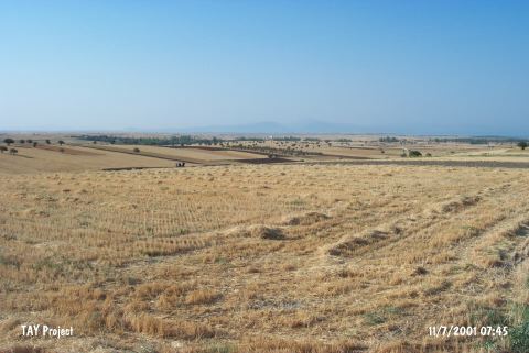 |
|
Type:
|
Flat Settlement |
|
Altitude:
|
1130 m |
|
Region:
|
Mediterranean |
|
Province:
|
Konya |
|
District:
|
Hüyük |
|
Village:
|
Çukurkent |
|
Investigation Method:
|
Survey |
|
Period:
|
Roman |
|
|
|
 |
|
| The surveys conducted under the direction of H. Bahar on behalf of the University of Selçuk at Çukurkent of the Höyük District of the Konya Province yielded some architectural fragments from the Roman Period. |
| Location: The site of Çukurkent lies close to the Beysehir-Sarkikaraagaç highway; 28-29 km northwest of the town of Beysehir; west of the city of Konya. It locates on a field in Bozyer Mevkii; 1 km away from Çukurkent Village; between the villages of Kireli and Yeniköy. |
| Geography and Environment: The information provided on the location of the site is limited. It is very close to the northwestern shore of Beysehir Lake. On Mellaart's map; the site is located on a flat area by the slopes of the Görünmez Mountains extending towards Beysehir Lake. Mellaart does not mention on what side of Çukurkent; the village the site is named after; this open-air site is located on. The finds were collected from a well-plowed field. |
| History: |
| Research and Excavation: |
| Stratigraphy: |
| Small Finds: |
| Remains: |
| Interpretation and Dating: |