| ©The Archaeological Settlements of Turkey - TAY Project | ||||||
|
|
||||||
Akçahöyük / Yeniköy |
||||||
|
|
||||||
| Ages | Maps | Photos | ||||
| Palaeolithic/Epipalaeolithic |
 |
 |
||||
|
|
||||||
|
Type:
|
Single Findspot | |||||
|
Altitude:
|
m | |||||
|
Diameter:
|
m- Direction: | |||||
|
|
||||||
|
Region:
|
Southeastern Anatolia | |||||
|
Province:
|
Gaziantep | |||||
|
District:
|
Oguzeli | |||||
|
Village:
|
Yeniköy | |||||
|
|
||||||
|
|
||||||
|
|
||||||
|
TAYEx:
|
Not visited - 19/8/2001 | |||||
|
|
||||||
|
Registration State:
|
Registered For detailed registration information please refer to Turkish pages. | |||||
 |
||||||
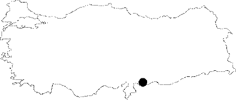
| Location: This site is located approximately 28 km southeast of the city of Gaziantep. It lies south of the town of Akçakoyunlu; near the village of Akçahöyük/Yeniköy and east of the Secir (Sacir) Stream. |
| Geography and Environment: The village of Oguzeli; formerly called Tilbasar lies on flat plain which is nourished by the Sacir Stream. Since the exact location of the site is unclear; a more detailed description of the setting cannot be provided. |
| Destruction Details: |