| ©The Archaeological Settlements of Turkey - TAY Project | ||||||
|
|
||||||
Çayönü |
||||||
|
|
||||||
| Ages | Maps | Photos | ||||
| Neolithic EBA 14C |
 |
 |
||||
|
|
||||||
|
Type:
|
Mound | |||||
|
Altitude:
|
810 m | |||||
|
Diameter:
|
m- Direction: | |||||
|
|
||||||
|
Region:
|
Southeastern Anatolia | |||||
|
Province:
|
Diyarbakir | |||||
|
District:
|
Ergani | |||||
|
Village:
|
Sesverenpinar | |||||
|
|
||||||
|
Destruction :
|
Natural causes | |||||
|
|
||||||
|
TAYEx:
|
Visited - 6/9/2001 | |||||
|
|
||||||
|
Registration State:
|
Registered For detailed registration information please refer to Turkish pages. | |||||
 |
||||||
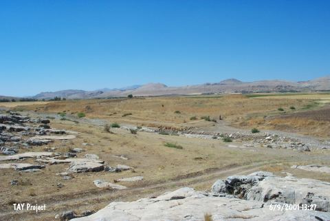
| Location: This mound site of Çayönü; which used to be called Kotaberçem or Çayboyu; lies northwest of the city of Diyarbakir; 7 km southwest of the town of Ergani and close to the village of Sesverenpinar (Hilar). It is possible to get to the site via the road leading to the Ilk Ögretmen Okulu (Teacher Training College). The survey code of the site is R 55 / 1. |
| Geography and Environment: The cultural depositional layer on this mound; which is 160 m north-south and 350 m east-west; is 4.5 m thick. The test trenches dug around the mound; especially on the northern side; indicate that the site extends beyond the stated measures. Bogazçay; which flows by the southern and western sides of the mound; eventually empties into the Tigris River. East of Bogazçay lies the seasonal Bestakot Stream. The south and southeastern sides of the mound are steeper than the other sides. The geomorphological research conducted on the mound and in the Ergani Plain in 1990-91 determined that the immediate surroundings of the cave at the end of the Pleistocene and the beginning of the Holocene were different than today. It has been proposed that there was a large flood in the Aceramic Neolithic Period which split the mound in two. The alluvial silt of the river; which meanders around the northern part of the mound; has created a terrace. Evidence shows that the Ceramic Neolithic settlement at the site was here. Excavations continued until the yellowish virgin soil appeared. The first inhabiters of the site thus settled on this natural alluvial terrace comprised of hard yellow soil. |
| Destruction Details: The mound is surrounded by barbed ware; it has been cut by the stream and it is being destructed by erosion [TAYEx 6.9.2001]. |