|
©The Archaeological Settlements of Turkey - TAY Project
|
|
|
|
|
|
Çayönü |
|
|
For site maps and drawings please click on the picture...  |
For photographs please click on the photo... 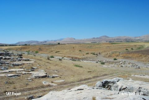 |
|
Type:
|
Mound |
|
Altitude:
|
810 m |
|
Region:
|
Southeastern Anatolia |
|
Province:
|
Diyarbakir |
|
District:
|
Ergani |
|
Village:
|
Sesverenpinar |
|
Investigation Method:
|
Excavation |
|
Period:
|
EBA I EBA II |
|
|
|
 |
|
| Location: This mound site of Çayönü; which used to be called Kotaberçem or Çayboyu; lies northwest of the city of Diyarbakir; 7 km southwest of the town of Ergani and close to the village of Sesverenpinar (Hilar). It is possible to get to the site via the road leading to the Ilk Ögretmen Okulu (Teacher Training College). The survey code of the site is R 55 / 1. |
| Geography and Environment: The cultural depositional layer on this mound; which is 160 m north-south and 350 m east-west; is 4.5 m thick. The test trenches dug around the mound; especially on the northern side; indicate that the site extends beyond the stated measures. Bogazçay; which flows by the southern and western sides of the mound; eventually empties into the Tigris River. East of Bogazçay lies the seasonal Bestakot Stream. The south and southeastern sides of the mound are steeper than the other sides. The geomorphological research conducted on the mound and in the Ergani Plain in 1990-91 determined that the immediate surroundings of the cave at the end of the Pleistocene and the beginning of the Holocene were different than today. It has been proposed that there was a large flood in the Aceramic Neolithic Period which split the mound in two. The alluvial silt of the river; which meanders around the northern part of the mound; has created a terrace. Evidence shows that the Ceramic Neolithic settlement at the site was here. Excavations continued until the yellowish virgin soil appeared. The first inhabiters of the site thus settled on this natural alluvial terrace comprised of hard yellow soil. |
| History: |
| Research and Excavation: The joint project conducted by the University of Chicago and the University of Istanbul aimed to understand the transition of the First Producers from hunting and gathering to herding and agriculture. The joint team surveyed the Diyarbakir; Sanliurfa; Siirt Provinces in 1963 and began excavation at Çayönü in 1964 [Çambel-Braidwood 1980:5-6]. The survey code of this site is R 55 / 1. A total of 16 seasons of excavation were conducted on the mound. Excavations at the site have been terminated since 1992 due to political activities in the area. A total of 4;654 square meters were excavated. The excavations were led by R. J. Braidwood and H. Çambel for many years but were taken over by M. Özdogan after 1986 and excavated until 1991. The team includes specialists both from Turkey and abroad and from various disciplines. Çayönü Project was supported by Karlsruhe Institute for Technology (Germany) between 1978-88 and by University of Roma (Italy) between 1989-91. After a long interlude, excavations has started in 2015 under the directory of A. Erim Özdogan. It takes place in the registered archaeological sites list prepared by Ministry of Culture and Tourism. |
| Stratigraphy: It is suggested that the site had been continuously inhabited from the Aceramic Neolithic Age to the Middle Age. |
| Small Finds: Pottery: Sherds were recovered from the layer III housing a grave. They consist of late and middle phase samples of the reserved slip decorated ware; early samples of the bell-shaped cups and samples of the red-black burnished Karaz ware. Metal: A bronze pin was recovered. This disc-headed pin bears the characteristics of EBA II and III. EBA pits were found. A bronze dagger was recovered from one of these pits. It is decorated with chevron. Human Remains: The 1968 excavation yielded a cist grave. The top and sidewalls of the grave were built by limestone plates. It houses single burial and grave goods. The pottery finds left as grave goods are comparable with Phase I of the Amuq Plain [Çambel-Braidwood 1980:21]. And a mining atelier was discovered on the southern slope. The slags are dated to 4320 BP + 60; 2709 BC [Özdogan (A) 1999:39]. |
| Remains: |
| Interpretation and Dating: It is noted that on the rocks of Çayönü and Hilar; a settlement was occupied by nomads during the EBA I and II; sometime between the beginning and midst of the third millennium BC. A. Özdogan reports that the northern part of the hill could have been used as a cemetery during the EBA II. The grave uncovered was not published in detail. |