| ©The Archaeological Settlements of Turkey - TAY Project | ||||||
|
|
||||||
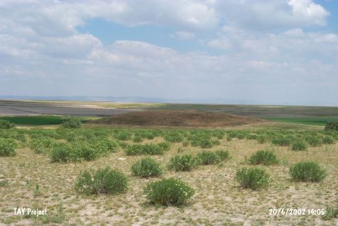
Çayir Höyük |
||||||
|
|
||||||
| Ages | Maps | Photos | ||||
| EBA |
 |
 |
||||
|
|
||||||
|
Type:
|
Mound | |||||
|
Altitude:
|
880 m | |||||
|
Diameter:
|
125 m- Direction: | |||||
|
|
||||||
|
Region:
|
Central Anatolia | |||||
|
Province:
|
Eskisehir | |||||
|
District:
|
Çifteler | |||||
|
Village:
|
Hayriye | |||||
|
|
||||||
|
Destruction :
|
Illicit Digging - Attention | |||||
|
|
||||||
|
TAYEx:
|
Visited - 20/6/2002 | |||||
|
|
||||||
|
Registration State:
|
For detailed registration information please refer to Turkish pages. | |||||
 |
||||||
| Location: |
| Geography and Environment: |
| Destruction Details: The mound has been seriously damaged by illicit digging. There is a pit with a diameter of 4 m and depth of 11.2 m on top of Çayir Höyük; which is 8 m in height. The treasure hunters dug virgin soil about 3 m and scattered the soil on mound [TAYEx 20.6.2002]. |