| ©The Archaeological Settlements of Turkey - TAY Project | ||||||
|
|
||||||
Çakmaktepe |
||||||
|
|
||||||
| Ages | Maps | Photos | ||||
| Palaeolithic/Epipalaeolithic |
 |
 |
||||
|
|
||||||
|
Type:
|
Single Findspot | |||||
|
Altitude:
|
1206 m | |||||
|
Diameter:
|
m- Direction: | |||||
|
|
||||||
|
Region:
|
Central Anatolia | |||||
|
Province:
|
Nigde | |||||
|
District:
|
Ulukisla | |||||
|
Village:
|
Altay | |||||
|
|
||||||
|
|
||||||
|
|
||||||
|
TAYEx:
|
Visited - 10/8/2002 | |||||
|
|
||||||
|
Registration State:
|
For detailed registration information please refer to Turkish pages. | |||||
 |
||||||
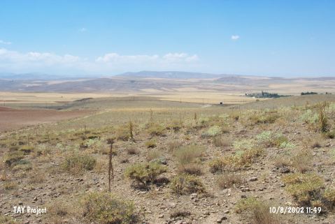
| Location: This open-air site is named after a small hill that lies south-southeast of the city of Nigde; west of the village of Altay and 6-8 km northeast of the town of Ulukisla. Minzoni-Deroche reports that this site is approximately 15 km (by highway) northeast of the town of Ulukisla. |
| Geography and Environment: Çakmaktepe; which is approximately 1;000 m above sea level is one of the hills southeast of the Bor Ova Plain. The literal name of Çakmaktepe; "flint-hill"; refers to the numerous deposits of black flint concentrated especially at the base of this hill. The quality of the flint is varied. All the chipped stone tools from this site are surface finds. The Eregli-Nigde railroad tracks pass by the base of Çakmaktepe. |
| Destruction Details: |