| ©The Archaeological Settlements of Turkey - TAY Project | ||||||
|
|
||||||
Civelek Magarasi |
||||||
|
|
||||||
| Ages | Maps | Photos | ||||
| Chalcolithic |
 |
 |
||||
|
|
||||||
|
Type:
|
Cave | |||||
|
Altitude:
|
1230 m | |||||
|
Diameter:
|
m- Direction: | |||||
|
|
||||||
|
Region:
|
Central Anatolia | |||||
|
Province:
|
Nevsehir | |||||
|
District:
|
Gülsehir | |||||
|
Village:
|
Civelek | |||||
|
|
||||||
|
|
||||||
|
|
||||||
|
TAYEx:
|
Visited - 28/7/2002 | |||||
|
|
||||||
|
Registration State:
|
Registered For detailed registration information please refer to Turkish pages. | |||||
 |
||||||
| Location: The site lies north of Nevsehir; 2.2 km north of Civelek Village; 4.8 km north-northeast of Gülsehir; at the southern ridges of Hirka Mountain; 7 km from Gülsehir District; at the northern bank of Halys. |
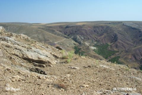
| Geography and Environment: The cave is located 600 m north of a water depot at Görlek Tepe; at the upper parts of the eastern slope of a ridged area. It was possible to reach the cave through a gallery; 14 km in length. The main living gallery measures 22x11 m. There are calcite pieces and debris fallen from the roof. Small galleries were observed. It was not possible to locate the main entrance; because some of the galleries were blocked by big rocks. The entrance might be closed thousands of years ago. |
| Destruction Details: |