| ©The Archaeological Settlements of Turkey - TAY Project | ||||||
|
|
||||||
Bogazköy / Hattusa |
||||||
|
|
||||||
| Ages | Maps | Photos | ||||
| EBA IA |
 |
 |
||||
|
|
||||||
|
Type:
|
Slope Settlement | |||||
|
Altitude:
|
990 m | |||||
|
Diameter:
|
m- Direction: | |||||
|
|
||||||
|
Region:
|
Black Sea | |||||
|
Province:
|
Çorum | |||||
|
District:
|
Bogazkale | |||||
|
Village:
|
Merkez | |||||
|
|
||||||
|
|
||||||
|
|
||||||
|
TAYEx:
|
Visited - 15/8/2003 | |||||
|
|
||||||
|
Registration State:
|
Registered For detailed registration information please refer to Turkish pages. | |||||
 |
||||||
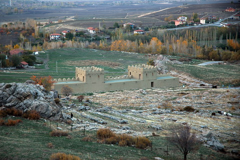
| Location: It is a big-sized settlement located east of the Bogazkale District; southeast of Sungurlu; southwest of the Çorum Province. The EBA settlement at Bogazköy/Büyükkaya was not evaluated separately; but as a part of the main settlement; although it lies on the other side of the strait. |
| Geography and Environment: It was re-known as the capital of the Hittite Empire during the second millennium BC; the site is located at the southern end of a long and wide valley where the stream of Budaközü passes through. There are many rocky hills; the biggest being Büyükkale (such as Yenicekale; Sarikaya; Nisantepe; Ambarlikaya; Mihrapkaya) on this lowland. Büyükkaya is in the far northeast and 750 m away from Büyükkale. A big cleft formed by the Büyükkaya/Budaközü Stream separates the main settlement from this location. The settlement at Bogazköy is situated in the triangular area between the streams of Budaközü and Kizlarkayasi. Particularly the rocky elevation so called Büyükkale looks like an acropolis with its deep clefts and it can be easily defended. The city suggested to be founded during the last phase of EBA lies on this rocky block and on the ridges of Büyükkaya and the lower city to the north of Büyükkale on a slope-like lowland inclining to the northwest [Bittel 1970:fig.5a]. It is suitable for occupation with its water resources and fertile land. It is believed that it was even richer in water and plantation during the third millennium BC. The EBA III and colonial period settlements are obscured by the remains of the Hittite Period. In the surrounding territory; outside Yerkapi; EBA sherds were found [Bittel 1970:map in fig 4.]. |
| Destruction Details: |