|
©The Archaeological Settlements of Turkey - TAY Project
|
|
|
|
|
|
Bogazköy / Hattusa |
|
|
For site maps and drawings please click on the picture...  |
For photographs please click on the photo... 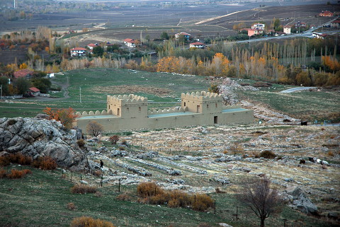 |
|
Type:
|
Slope Settlement |
|
Altitude:
|
990 m |
|
Region:
|
Black Sea |
|
Province:
|
Çorum |
|
District:
|
Bogazkale |
|
Village:
|
Merkez |
|
Investigation Method:
|
Excavation |
|
Period:
|
Early Iron Age Late Phrygian Middle Phrygian |
|
|
|
 |
|
| Location: It is a big-sized settlement located east of the Bogazkale District; southeast of Sungurlu; southwest of the Çorum Province. The EBA settlement at Bogazköy/Büyükkaya was not evaluated separately; but as a part of the main settlement; although it lies on the other side of the strait. |
| Geography and Environment: It was re-known as the capital of the Hittite Empire during the second millennium BC; the site is located at the southern end of a long and wide valley where the stream of Budaközü passes through. There are many rocky hills; the biggest being Büyükkale (such as Yenicekale; Sarikaya; Nisantepe; Ambarlikaya; Mihrapkaya) on this lowland. Büyükkaya is in the far northeast and 750 m away from Büyükkale. A big cleft formed by the Büyükkaya/Budaközü Stream separates the main settlement from this location. The settlement at Bogazköy is situated in the triangular area between the streams of Budaközü and Kizlarkayasi. Particularly the rocky elevation so called Büyükkale looks like an acropolis with its deep clefts and it can be easily defended. The city suggested to be founded during the last phase of EBA lies on this rocky block and on the ridges of Büyükkaya and the lower city to the north of Büyükkale on a slope-like lowland inclining to the northwest [Bittel 1970:fig.5a]. It is suitable for occupation with its water resources and fertile land. It is believed that it was even richer in water and plantation during the third millennium BC. The EBA III and colonial period settlements are obscured by the remains of the Hittite Period. In the surrounding territory; outside Yerkapi; EBA sherds were found [Bittel 1970:map in fig 4.]. |
| History: |
| Research and Excavation: It was discovered in 1834 by E. Chantre, and later on attracted the attention of many travellers and scientists. It was excavated in 1907 by O. Puchstein, and in 1906 and 1911-12 by H. Winckler and Makridi Bey, followed by K. Bittel from 1931 except the years of the 2nd World War. Following Bittel, P. Neve excavated Bogazköy/ Hattusa in between 1964 and 1993. From 1994 to 2006 J. Seeher led the excavations. Since 2007, work at Bogazköy/ Hattusa has been carried out under the directory of A. Schachner.The excavations conducted under the direction of J. Seeher were also expanded to expose the pre- and post-Hittite Periods other than the Hittite settlement, during which main activities were concentrated on Büyükkaya. The excavations has been directed by A. Schachner since 2006. It takes place in the registered archaeological sites list prepared by Ministry of Culture and Tourism. |
| Stratigraphy: The Early Iron Age and Phrygian Period layers of the city were revealed during the excavations at Büyükkaya and Büyükkale. Reoccupation on Büyükkale after the Hittites was found at the layers IIa-b (Middle Iron Age-Early Phrygian) and Ia-b (Late Iron Age-Late Phrygian). There is no interruption between the layer II and underlying Hittite layer. The layer II was founded immediately upon the layer III, and it is from the Phrygian Period. The Phrygian settlement at Bogazköy has three phases together with the traces of a settlement dating back to an earlier period found at Büyükkaya (Early Iron Age-Dark Ages). Following the collapse of the Hittite Empire, the ridges of Büyükkaya didn't remain abandoned for so long. After a short while, inhabitants of the early Dark Ages (12th century BC), the Early Bronze Age (after 1200/1180 BC) were settled here. This settlement has two phases, with the later one having two development stages. The layers belonging to that period at the Middle Plateau reach up to a thickness of 1.5 m. A series of pits uncovered at the Lower Plateau indicate further settlement activities in this section of Büyükkaya during that period. The "Dark Ages" settlement at Hattusa during the Early Iron Age is not only limited to Büyükkaya. Evidence of this period has also been uncovered near the House on the Slope in the Lower City, on the rocky platform of Büyükkale, and in the area of Temple 7. With the start of the Middle Iron Age in the 9th century BC, a somewhat larger settlement which covered the entire hill at Büyükkaya developed. Additionally, the Lower City and Büyükkale had been inhabited during the 8th century BC. A citadel was constructed in the early/mid 7th century on Büyükkale during which the settlement at the Lower City was reduced, and Büyükkaya was abandoned. It is suggested that these actions might have been precautions taken against any potential attacks by Cimmerians. Other than the citadel at Büyükkale, which was densely built up, some residences were also revealed at the Southern Citadel and in the vicinity of Nisantas and above the Eastern Ponds. This Middle and Late Iron Age settlement is traditionally term "Phrygian". However, it was concluded that it is not feasible anymore to term such a culture remaining within the Kizilirmak (the Halys) bend with a wide distribution area towards the south as "Phrygian", and it would be much appropriate to use the term "Iron Age", which represents a general concept and which is a neutral term, instead of an incorrect ethnic identification. |
| Small Finds: Architectural Material: The remains at Büyükkaya from the Early Iron Age indicate that both mudbrick on stone foundations and pile construction techniques were used together. Also found are big pits with a size ranging from 6 to 8 m, partly including wooden remains. A. von den Driesch, who studied on the animal bones recovered from these pits, mentions some evidence indicating that the pits were used for pig housing [Seeher 2000:19]. The architecture of the Middle Iron Age is very simple; in general the structures have single rooms in an irregular plan with a size ranging from 6 to 8 m [Seeher 2000: pic. 10]. Based on the single face foundation walls, these structures were partly seated into the soil. This is particularly true for the structures located on the slope. Their superstructures are considered to have been mainly constructed by timber and mudbrick, and contrary to the houses of the BKI (Buyukkale I) phase at Büyükkale, restricted number of rubble stones were found inside the structures. Some wall remains, preserved to a limited extent, have spaces for vertical beams. Some narrow stone benches with soil plaster were found in front of the walls inside the houses, presumably used for seating or sleeping. Cupola furnaces are common, but open hearth places were also found. The most prominent characteristic of the Middle Iron Age settlement, as in the Early Iron Age (=Dark Ages) settlement, is the presence of pits, which were dug at almost all levels. It is usual to find 25-30 pits within a trench of 10x10 m. The pits are not deeper than 60-80 cm, but they have various diameters and shapes. Their function is uncertain; it is believed that they were individual storage pits, which later on became dysfunctional so that they were filled with garbage and soil. It is uncertain if Büyükkaya was fortified during the early Middle Iron Age. It seems that the city walls of Hittite were no longer functional as some of the Iron Age structures were seated on the stone foundations of the Hittite fortifications. It changed during the second half of the Middle Iron Age at Büyükkaya, which is almost contemporary with the first half of the Büyükkale II. The settlement was deserted to a great extent, and the Upper Plateau was enclosed by a city wall towards the Middle Plateau to the east. This section, which measures 50x40 m in dimensions, includes mostly structures with single rooms; however most of the plateau appears as if it had never been occupied. It seems that it was used for sheltering purposes with spaces allocated for cattles/sheep&goats, and food and drink storage. It also functioned like a sanctuary because a stele made of sandstone was found fallen in front of the rear wall in the structure with one side being open. In front of the walls lie low benches. The open entrance on the left leads to the stele through a stone pavement. Next to the pavement rises a dressed mass of rock which was included in the structure. A similar Iron Age structure dating to the late Büyükkale phase II was unearthed in front of the entrance to the eastern magazine of the Temple 1 in the Lower City at Bogazköy. Based on the finds, it was described as a temple, and identified as a mountain temple due to its specific status on the Upper Plateau. The rock mass with a leveled top on the right side of the building may be an altar. Similar treatments are also observed in the core Phrygia in Anatolia. The earlier buildings of Büyükkale II on the Upper Plateau were all demolished as a result of a heavy fire. In addition to the small fortified settlement on the Upper Plateau, there are some other buildings dating to the same period on the section of the Hittite East Gate at Büyükkaya. The remaining section of Büyükkaya was deserted as the inhabitants of that period moved down to the Lower City and Büyükkale. The phases of Büyükkale IIa and I yielded very restricted number of finds scattered around on Büyükkaya. In 1999 a large underground cereal storage was found in the lower city behind Postern Wall of the outer fortifications. Since it was built underground a special isolation against water was performed on external edges. There is an additional 50 cm thick wall by the external wall, which is approximately 5 m high at some points. This wall almost acts like a cover wall, there is a very thick layer of clay soil behind it, and this way it protects the cereal storage from the effects of the water running from above and below the ground [Seeher 2002:189]. Based on the aerial photographs previously taken excavations were performed on the plateau at the peak point of the city in 2000, which revealed 4 ponds built for the purpose of storing water. These are named South Ponds, and unlike previously known Hittite ponds and other ponds of Hattusa these do not possess artificial pond borders. Due to the presence of impermeable clay soil on the plateau the ponds were built by digging the ground. Although the other ponds at Hattusa are not deeper than 2-3 m these reach a depth of 8 m. The fact that not one but two adjacent ponds were built maybe due to security concerns by Hattusa engineers. When these 4 are added the total number of ponds at Hattusa reaches nine [Seeher 2002:190-191]. As a result of researches performed in 2001 it was found that the number of ponds is actually 5 and not 4. The reason why pond #2 is different than others was because there was an underground silo underneath the pond before it was built there. Since the pond #2 cut through the south end of the silo, the dimensions of the silo could not be identified. Its construction date maybe older than the others. In 2001 the excavations were initialized at the Upper West City and presence of two Hittite phases was identified. The upper phase consists of multiple room structure foundations right below the surface. The Iron Age presence at this phase consists only of a few holes. It is assumed that Iron Age remains were destroyed through erosion and agriculture [Seeher 2003:106]. During the studies carried out in 2009 in Central Plateau of Upper City, the structural properties of the plan, the estimated size, and the order of the rooms learned from the excavation of the building which is regular planned and symmetrical construction, shows similarity with some building structures studied in Hattuşa, especially in Lower City during earlier excavations. The building shows properties of symmetry which is unseen Hittite cities before [Schachner 2011.212-213]. Scattered wall pieces and partial stone pavements are seen at some parts in the Northern Part of East Trench at Lower City in 2009. Considering metal finds and some painted pottery samples encountered on this layer, it is believed to be from Iron Age, or even from Büyükkale II and I Phases. Some finds are encountered which are believed to be from Iron Age inside a layer of intense debris beneath the level where graves were found in the West Trench. Wet weak and destructed pieces of wall, some pieces of pottery and bronze finds reflecting the features of the period imply a scattered and destructed Iron Age usage in these areas as is the case in the Eastern Trenches [Schachner 2011: 214-216]. Some finds are encountered which are believed to be from Iron Age inside a layer of intense debris beneath the late period graves close to the surface in the West Trench of Lower City. The regularly shaped walls which are detected in the area where the architecture plan could not be defined clearly, the structure in the lower layers is multi-phased. It is believed to be part of Middle (?) Hittite period [Schachner 2011:216]. In the 2010 excavations, the "megaron-type" structure belonging to IA which was exposed during 1960s campaign, was reexcavated and the connection between the new and old excavations was fulfilled. Considering the L shaped wall and typical IA painted wares found in the plan square of 295/361, on the slope and potsherds recovered from the structures which belong to two different levels and the painting style suggest that it is dated to the periods of Büyükkale II and I; i.e. 8th-6th centuries BC [Schachner 2013:469]. During the 2011 studies, an urn dated to IA was recovered. A cremation burial was found inside the urn which was made out of polished grey paste. With this new finding, it was understood that IA necropolis extends towards the south. Under the rubble stone layer measuring 2 m in thickness on the south of Kesikkaya, 3 different architectural layers were discovered. Two of the layers are dated to IA while the third one belongs to Hittite period. As the thick soil layers seen on the profiles of the excavation area in 2010, this area hasn't been used for a long time after Hittite period but it was occupied again in IA. Based on the potsherds recovered in small quantity, both of the layers belong to the late phases of IA in Bogazköy. IA level is represented by a large structure with at least five rooms. During the construction of this structure, the Hittite rampart was reused and the structure leaning on this rampart was built on the slope descending towards the east [Schachner 2013:297-298]. Pottery: Outcomes from the analyses on the ceramic finds indicate that the Middle Iron Age settlement was continuation of an earlier settlement. Although there is a short hiatus between these two periods, connections clearly indicate that majority of the ceramic inventory from the Büyükkaya Phase of the 9th century BC may have been derived from the Dark Age ceramics. The ceramics of the Büyükkaya Phase from the 9th century BC are very similar to the 8th century BC material at the Kizilirmak Bend (Büyükkale II, Alisar IV c), and somewhat pioneer of it. Therefore, it has been suggested that the ceramics traditionally called Phrygian should have been interpreted as an outcome of an autochtonous cultural development not of a migration. This local tradition can be unexpectedly traced back; some familiar examples of the Early and Middle Bronz Age pottery of the Central Anatolia are observed in the ceramic reportoir of the Dark Age, but they are not available in the Late Bronze Age, which bears the imprint of the Hittites [Seeher 1999:236 vd]. People who kept the aforesaid culture maintained the Early and Middle Bronze Age traditions outside the core Hittite region, and penetrated into the Central Anatolia following the collapse of the Hittite Empire. It is highly probable that they were either Kaska people who inhabited the Northern Anatolia during the 2nd Millennium BC or some other tribes. Those tribes didn't arrive in Hattusa as invaders, instead they took shelter in the city which had been already abandoned. Many vessels were found in situ inside the structures of the early phase of Büyükkale II on the Upper Plateau, reflecting well the ceramic of their period. They represent goats and deers in silhoutte decorations, a typical feature of the painted pottery. However, no animal depictions in dark contours and light paints, which are observed in the middle of Büyükkale Phase II are found. In 2003 sherds that were dated to "Dark Ages" were found on the erosion deposit over the Hittite layers and inside the deep stream beds derived from heavy flooding (middle and late phases of Early Iron Age - 11-10th century BC). Handmade. dark red paint decorated, beak shaped spouted vessels with ear shaped knobs on both sides are among interested specimens of the period [Seeher 2005:353]. In 2010, it was found out that a high density of rubble stones and amorphous wares discovered in the West Trench were carried by erosion and only at this level some IA potsherds mixed with Hittite pottery were found. Therefore, it is suggested that these stone alignments could be belong to the bank of the erosion canal belongin to the Büyükkale I phase of IA (about 7th/6th centuries BC). [Schachner 2013:463]. Bones: Animal bones found at the layers of the Dark Age are more intense than usual. It is believed that this material will contribute much to remodelling of climate and economy of the period. Metal: Plenty of finds dating to this period and related with metal crafting were recovered from the Middle Plateau. They include iron, bronze, and lead finds and melting pots and broken blowpipes as well as places for hearths. Excavations performed in 1999 yielded 22 arrowheads. Iron arrowheads were found besides Scythian type arrowheads [Seeher 2001:306]. A 7th-6th century BC dated fibula was revealed inside the soil containing mortar deposit just above Hittite architectural remains in the east section during 2006 Sarikale plain excavations [Schachner 2008:168]. Plant remains: Hundreds of tons of carbonized cereal was found in the large underground cereal silo behind the Postern Wall at lower city in 1999 [Seeher 2002:189]. Other: In addition to above finds, antler handles produced for tools by blacksmiths and many incomplete specimens of such handles and surplus fragments of antler were brought to light. Stone seal on which a typical lion and a bird were depicted unearthed in 1999 is a remarkable sample [Seeher 2001:306]. A cuneiform tablet is found in 2009 which is part of a letter written to the commander of MESEDI troops written by the top administrator of palace officers of the Middle Plateau of Upper City [Schachner 2011.213]. |
| Remains: |
| Interpretation and Dating: The Büyükkaya excavations represent first evidence of a settlement belonging to the Dark Age during the Early Iron Age in Hattusa ant its vicinity. A short while after the Hittites faded from the scene, the site witnessed an almost uninterrupted settlement lasting from the 12th century BC until the 8th century BC. Based on the analyses of the finds, it appears that the communities living here during the Dark Age kept an earlier Anatolian culture alive, which originated from the Early and Middle Bronze Ages. The Iron Age settlement continued with a period so called Early Phrygian cultural complex, known from Bogazköy and neighbouring settlements. With the help of the Büyükkale cultural sequence, it is possible to observe that a majority of the material culture of the period developed during the Dark Age. The radiocarbon dates of the layers identified as the Büyükkaye Phase of the Middle Iron Age indicate that this period is dated to the 9th century BC (initially it may be 10th century BC) [Seeher 2000:23, draw. 1]. Other specimens taken from the Early Iron Age layers verify the hypothesis that this period so called the Dark Age started immediately after the collapse of the Hittite Empire and lasted at least until the 10th century BC. The artifacts of the material culture dating to the Dark Age presents a totally different appearance from the artifacts belonging to the Period of the Hittite Empire. It is characterized with pottery finds, which are all particularly hand-made with a wide range of forms. 14C measurements were performed on the cereals revealed inside the underground cereal storage behind the Postern Wall at the lower city in 1999 and it was found that these belong to 16th century BC. Before that it was assumed that the wall consrtruction belonged to late 15th century - early 14th century BC, but following the measurement it was found that it is at least 100 maybe 200 years older than that [Seeher 2002:189]. |