| ©The Archaeological Settlements of Turkey - TAY Project | ||||||
|
|
||||||
Salat Tepe |
||||||
|
|
||||||
| Ages | Maps | Photos | ||||
| Chalcolithic EBA IA |
 |
 |
||||
|
|
||||||
|
Type:
|
Mound | |||||
|
Altitude:
|
510 m | |||||
|
Diameter:
|
m- Direction: | |||||
|
|
||||||
|
Region:
|
Southeastern Anatolia | |||||
|
Province:
|
Diyarbakir | |||||
|
District:
|
Bismil | |||||
|
Village:
|
Yukarisalat | |||||
|
|
||||||
|
Destruction :
|
Contemporary Settlements | |||||
|
|
||||||
|
TAYEx:
|
Visited - 9/9/2001 | |||||
|
|
||||||
|
Registration State:
|
Registered For detailed registration information please refer to Turkish pages. | |||||
 |
||||||
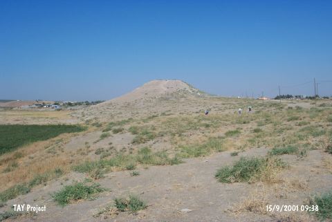
| Location: The site is located southeast of Yukarisalat Beldesi; in the district center of Bismil in the province of Diyarbakir. Salat Tepe is situated where the Salat Çay; a tributary of the Tigris flowing from the north; begins to wind towards the east; 14 km from Bismil and 35 km from the town of Batman. |
| Geography and Environment: The mound measures 115x100 m and; at a height of 555 m above sea level; rises 30 m above the valley floor; overlooking the valley and the plain. To the east of the site is Misevre Tepe and to the south is Ziyaret Tepe. The north of the plain is known as the "Mollaali Gölü Mevkii" and the northwest as the "Sor Gölü Mevkii" [Ökse 1999:345]. |
| Destruction Details: There is a cemetery on east-northeast skirt of the mound [TAYEx 9.9.2001]. |