|
©The Archaeological Settlements of Turkey - TAY Project
|
|
|
|
|
|
Salat Tepe |
|
|
For site maps and drawings please click on the picture...  |
For photographs please click on the photo... 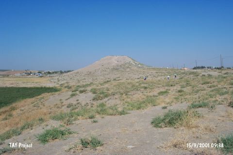 |
|
Type:
|
Mound |
|
Altitude:
|
510 m |
|
Region:
|
Southeastern Anatolia |
|
Province:
|
Diyarbakir |
|
District:
|
Bismil |
|
Village:
|
Yukarisalat |
|
Investigation Method:
|
Excavation |
|
Period:
|
|
|
|
|
 |
|
| Location: The site is located southeast of Yukarisalat Beldesi; in the district center of Bismil in the province of Diyarbakir. Salat Tepe is situated where the Salat Çay; a tributary of the Tigris flowing from the north; begins to wind towards the east; 14 km from Bismil and 35 km from the town of Batman. |
| Geography and Environment: The mound measures 115x100 m and; at a height of 555 m above sea level; rises 30 m above the valley floor; overlooking the valley and the plain. To the east of the site is Misevre Tepe and to the south is Ziyaret Tepe. The north of the plain is known as the "Mollaali Gölü Mevkii" and the northwest as the "Sor Gölü Mevkii" [Ökse 1999:345]. |
| History: |
| Research and Excavation: The site of Salat Tepe was first investigated by G. Algaze and his team in 1989 during their survey in the region [Algaze et al. 1991:213]. It was surveyed under the directorship of T. Ökse in 1998 and 1999. In 2000-2002; during the Salvage Project of the Archaeological Heritage of the Ilisu and Carchemish Dam Reservoirs; it was excavated for Diyarbakir Museum; by a team under the directorship of T. Ökse. Excavations continued in 2005; after two years of interruption [Ökse 2006:12]. The excavations were completed in 2012. It takes place in the registered archaeological sites list prepared by Ministry of Culture and Tourism. |
| Stratigraphy: During the 1999 survey; surface materials were collected from the slopes of the mound. The pottery from the slopes were collected in separate groups; but no significant distribution ratios according to periods were observed in the pottery from the south and west slopes; suggesting that there was a homogeneous settlement here in all periods during which the mound was occupied. Examination of the pottery indicates settlement at Salat Tepe from the 4th millennium BC to the end of the Hellenistic period [Ökse et al. 2001:620]. The 2000 season excavation had the objective of understanding the stratigraphy of the late occupation on the site. Four architectural levels were identified: Level I was dated to the Late Antique Period (5th-7th centuries AD) and levels II and III to 3rd and 2nd centuries BC and earlier. It appears that the summit of the mound was not settled from the 7th century AD onwards and it was used as a cemetery in the Medieval Period [Ökse-Alp 2002:668-669]. As a result of the 2012 studies, the stratigraphy is as follows; Period I Chalcolithic Settlement (6000-3000 BC): This period is divided into four sub-periods. Period IA Halaf-Ubaid Transition Period, Period IB Late Ubaid, Period IC Late Chalcolithic/Uruk, Period ID Late Chalcolithic-EBA Transition Period. Period II BA Settlement (2400-1400 BC): Period IIA Akkadian and Post-Akkadian period, Period IIB Old Assyrian Period, Period IIC Old Babylonian- Early Mitanni Period. Period III IA Settlement (1050-330 BC): Period IIIA Early IA, Period IIIB Neo-Assyrian Period, Period IIIC Post-Assyrian/Persian Period. Period IV Hellenistic-Roman and Middle Age Settlement (330 BC-1500 AD): Period V New Age- Modern Period Cemetery [Ökse 2013:45-46]. |
| Small Finds: Architecture: In 2012, it has been understood that Level 5 is represented by the structures used in the years of 2200-2100 BC (EBA IVB) based on the result of the radiocarbon dating. The walls of the structures that lean on the upper part of the hill were bonded neatly inside while the external surfaces look bumpy. This suggests that these structures were the houses sit on the slopes. According to this evidence, the area which the structure covers was dug into the western slope before the structures of level were built and then the eastern part which forms a deep profile was erected inside with mudbrick. The north and south walls of the structures were buried in half into soil and the west walls facing to the valley were completely erected on the surface. Narrow streets covered with small pebbles separated the structures. There are window and door openings on the wall of the structures. The window openings are in narrow square shape and doorstones covered with small pebbles and jamb stones were encountered at the entrance of the doors. The structures, which were damaged by earthquake, underwent a fire. The damaged walls were renewed in the transition period from Early BA to MBA (about 2100-1900 BC.). Level 6 consists square shaped structures with mudbrick walls erected on the thick ashy layers on the hill. This level is dated to EBA IVA period [Ökse 2013:44-45]. During the 2013 studies, architectural remains belonging to EBA were exposed in the trenches on the hill. In Trench K12, two walls belonging to EBA I-IIA were recovered. Three quadrangular rooms aligned side by side were found in Trench J12. There are rounded hearths on the floor of these rooms. The floors of hearts were paved with pebbles. At the corners, there are semi-rounded storage units. Ground stones and pestles were found in these units. The structures belonging to Level 7 and 8 were covered with an ashy fill. A great number of pits were exposed in these levels. The Level 6 structures were built on this fill. The settlement was not inhabited during EBA IIB-III. It was reoccupied in EBA IVA (Late Akkad Period, 2400-2200 BC). Level 6 is characterized by low walls consisting of a couple of mudbricks. In Trench K-L 11, a structure showing different architectural characteristics was exposed. The foundations of this structure were built quite large limestone blocks placed on top of each other. The mudbrick walls were erected on these blocks. In Phase EBA IVB (after Akkad Period), Level 5 structures built on the level that was destroyed by an earthquake and fire were unearthed. Near the north wall of the structure in Trench L11, small pits were exposed at the foundation level. Bone fragments belonging to piglets, cattle and deer were found in these pits. These pits resemble to the building rituals known from the Hittite and Hurrian texts. Two or three roomed structures built in this phase are separated from each other by narrow roads paved with loam and small pebbles. It was observed that most of the walls were placed on the walls belonging to Level 6. Based on the radiocarbon analysis, Level 5 is dated to 2150-2000 BC (EBA IVB) [Ökse et al. 2015]. Pottery: The 16 sherds belonging to the Early Bronze Age were divided into five groups: Standard Ware: The sherds of this group; also known as "plain simple ware"; have fine sand and mica inclusions; are wheel-made; hard fired without reduction; and their surfaces are light reddish brown in color. Among these finds there are sherds of a large and smaller bowls with rim thickened on the outside; and a base sherd from a footed vessel. Fine Ware: The four sherds representing this group are wheel-made; hard fired without reduction; and of reddish brown or buff-colored fabric. In the breaks can be seen fine sand and mica; occurring naturally in the clay. Wheel marks remain on the interior surfaces; while the exterior surfaces were generally wet-wiped. The sherds belong to two small pots; a small bowl with direct tapering rim and a small bowl of the type called "cyma recta". Metallic Ware: This type is represented by three sherds. Their fabric contains a large quantity of fine sand and a small quantity of mica inclusions; and the vessels were fired at a very high temperature. Wheel marks can be seen particularly on the interior surfaces. Two of the examples are gray in color; and the third is gray with red mottling. The forms of the sherds were identified as a large jar with rim thickened on the outside; a short necked jar with a slightly thickened out-turned rim and a sherd from a flat base probably of a goblet. Ninevite 5 Ware: This group is represented by a sherd of a bowl with direct rim. The sherd is of very fine paste; with distinctive wheel marks on both interior and exterior surfaces; the fabric color is very light brown on the outside and pink on the inside. The vessel was fired at a very high temperature without reduction. On the exterior surface there are two parallel grooves. Coarse Ware: The largest group of the surface finds comprises the handmade cooking pots. The fabric has a large quantity of fine sand; small and medium-sized grit particles; and usually fine-cut chaff-temper and fine mica; two sherds have quartz inclusions. The fabric colors are pinkish buff; light brown and gray. The vessels were fired at a high temperature and; apart from one; are all reduced. None are slipped; and all have varying colors on the surfaces. The exterior surfaces and inner rims of three examples are lightly burnished. The sherds belong to pots with triangular lugs on the rims; pots with rounded rims thickened on the outside and coarse handmade pots with out-turned rims [Ökse et al. 2001:628-632]. During 2005 season approximately 600 square meters of the mudbrick building was excavated and small amount of EBA II-IV potsherds (dark rim orange rend pots and metallic ware) were collected in addition to the large number of MBA potsherds [Ökse 2006:12].: During the 2011 studies, vessel types and ware groups belonging to Phase III / IV of EBA were found in high density in the ashy fire fill in the building level 5 [Ökse et al. 2013:369]. During the 2012 studies, it has been seen that pottery of Level 5 and 6 consist of cooking pots with globular body and triangle shaped lugs on their rims. Apart from these pots, red-brown slipped and burnished vessels (red-brown burnished ware) and buried large jars which were probably used for storing water or food were recovered. Among the elaborate vessels, there are dark rimmed orange bowls, metallic wares and light beige greenish small vessels (plain Ninive V), sherds belonging to pedestals with pattern burnished or comb decoration and a sherd belonging to smeared wash ware. These wares prove that this level is dated to the last centuries of EBA [Ökse 2013:45]. The majority of potsherds belonging to Level 7 found in 2013 consist of handmade vessels known from Late Chalcolithic Period. In the uppermost fill of Trench J12, Nineveh-V wares with flat surface were recovered. These different types of vessels show that these structures were used during 3100-2900 BC (Late Chalcolithic-EBA transition / EBA IA). Most of the vessels found in the structure in Trench K-L 11 comprise of simple wares that were frequently used during EBA in North Mesopotamia. Level 5 wares, on the other hand, consist of coarse samples of Red Brown Wash Ware, Red Brown Burnished Ware, Early Jazirah Gray Burnished Wares and Dark Rimmed Orange Bowls [Ökse et al. 2015:24, 26, 29]. Chipped Stone: On the south slope of the mound; a piece belonging to a broad flint blade was found. The technique of this type of flint tool had its origins in the Upper Palaeolithic; although in geographical terms and method of usage; flint tools are represented in high numbers from the beginning of the Neolithic to the end of the Bronze Age. As a result of this; the dating of the tool is not clear [Ökse et al. 2001:637;638]. |
| Remains: |
| Interpretation and Dating: The relatively small amount of pottery from Salat Tepe dating to the Early Bronze Age; compared with the amounts from other periods; suggests that this period at the site was not well represented. The cooking-pots with triangular lugs and out-turned rims are of a form that was used in a fairly wide geographical area throughout the Early Bronze Age. The fact that the sherd from a Ninevite 5 bowl and the examples of fine ware have forms that were commonly produced in the Early Bronze Age I-II; and; in particular; the dating to the Late Uruk period of forms found in Northern Mesopotamia; does indicate that Salat Tepe was settled from the early phases of the Early Bronze Age onwards. According to the dating of parallels for the Metallic Ware to the end of the Early Bronze Age in other settlements; it is thought that the occupation at Salat Tepe continued up to the end of the Early Bronze Age [Ökse et al. 2001:632]. |