| ©The Archaeological Settlements of Turkey - TAY Project | ||||||
|
|
||||||
Ziyaret Tepe |
||||||
|
|
||||||
| Ages | Maps | Photos | ||||
| EBA IA |
 |
 |
||||
|
|
||||||
|
Type:
|
Mound | |||||
|
Altitude:
|
500 m | |||||
|
Diameter:
|
m- Direction: | |||||
|
|
||||||
|
Region:
|
Southeastern Anatolia | |||||
|
Province:
|
Diyarbakir | |||||
|
District:
|
Bismil | |||||
|
Village:
|
Tepe | |||||
|
|
||||||
|
|
||||||
|
|
||||||
|
TAYEx:
|
Visited - 10/9/2001 | |||||
|
|
||||||
|
Registration State:
|
Registered For detailed registration information please refer to Turkish pages. | |||||
 |
||||||
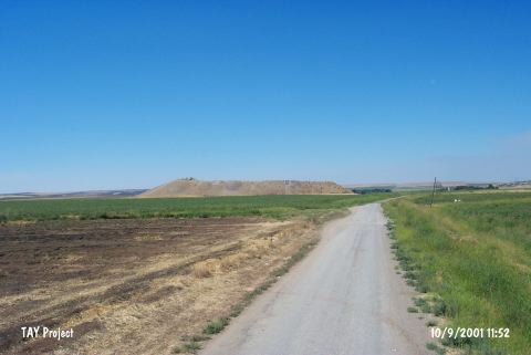
| Location: It is located 20 km west of the joining point of Tigris and Batman rivers; immediate east of the town of Tepe; east of the district of Bismil in the province of Diyarbakir. The mound; which lies on the southern bank of Tigris; will be on the edge of the dam lake after the construction of Ilisu Dam and it is reported that the site may be partly effected as the water level rises [Matney 1998:7]. |
| Geography and Environment: It is one of the large mounds that lie on the wide and low terraces to the north and south of Tigris flood plain. The mound is located in a fertile area as well as at a strategical point that controls the east-west traffic on the Tigris. A modern road passes from the immediate north of it. The settlement consists of a mound (acropolis) on the northern section and a lower town covering an area of 29 hectares on three sides of it. The mound itself covers 3 hectares and rises about 22 m above the plain level [Matney 1998:8]. It is reported that there is a modern cemetery area and illicit digging pits to the north of the mound; and that the villagers are removing stones from it. The southern section of the mound was also cut during the construction of a road [Matney 1998:15; Matney-Somers 1999:203; 208]. |
| Destruction Details: |