|
©The Archaeological Settlements of Turkey - TAY Project
|
|
|
|
|
|
Ziyaret Tepe |
|
|
For site maps and drawings please click on the picture...  |
For photographs please click on the photo... 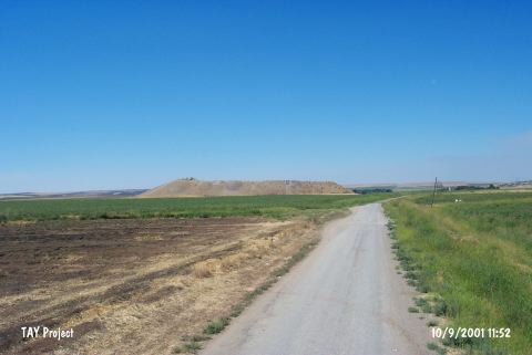 |
|
Type:
|
Mound |
|
Altitude:
|
500 m |
|
Region:
|
Southeastern Anatolia |
|
Province:
|
Diyarbakir |
|
District:
|
Bismil |
|
Village:
|
Tepe |
|
Investigation Method:
|
Excavation |
|
Period:
|
Early Iron Age New Assyrian Empire Period |
|
|
|
 |
|
| Location: It is located 20 km west of the joining point of Tigris and Batman rivers; immediate east of the town of Tepe; east of the district of Bismil in the province of Diyarbakir. The mound; which lies on the southern bank of Tigris; will be on the edge of the dam lake after the construction of Ilisu Dam and it is reported that the site may be partly effected as the water level rises [Matney 1998:7]. |
| Geography and Environment: It is one of the large mounds that lie on the wide and low terraces to the north and south of Tigris flood plain. The mound is located in a fertile area as well as at a strategical point that controls the east-west traffic on the Tigris. A modern road passes from the immediate north of it. The settlement consists of a mound (acropolis) on the northern section and a lower town covering an area of 29 hectares on three sides of it. The mound itself covers 3 hectares and rises about 22 m above the plain level [Matney 1998:8]. It is reported that there is a modern cemetery area and illicit digging pits to the north of the mound; and that the villagers are removing stones from it. The southern section of the mound was also cut during the construction of a road [Matney 1998:15; Matney-Somers 1999:203; 208]. |
| History: |
| Research and Excavation: It was discovered by Kessler in 1980, and visited in 1989 during a survey conducted in the area of the Ilisu Dam under the direction of G. Algaze. In 1997 a team under the direction of T. Matney and with the contribution of G. Algaze initiated systematic surveys at three different locations of the settlement, including the hill, the lower town and the slopes. In 1998, a geomorphological survey was conducted in four different sections of the settlement using magnetic methods. The excavations started under the direction of Matney in 2001. It takes place in the registered archaeological sites list prepared by Ministry of Culture and Tourism. |
| Stratigraphy: It appears that Ziyaret Tepe had been extensively occupied during the Middle and Neo-Assyrian Period, and that the city was an important garrison town with an acropolis and a lower town. Based on the sherds collected during the surveys until 2002, following periods were identified: Late Neolithic/Early Chalcolithic Period (ca. 6000-5000 BC) Middle Bronze Age (ca. 2000-1600 BC) Late Bronze Age (ca. 1300Ğ1200/1100 BC) Early Iron Age (ca. 1200/1100Ğ900 BC) Late Iron Age (ca. 900Ğ600 BC) Late Roman Sasanid/Early Islamic Period [Matney 1998:11-14]. Surface finds indicate that the mound had not been inhabited after the Iron Age, and there are Late Neolithic/Early Chalcolithic Period finds in addition to the MBA finds on the northern and western slopes, and the southern slope did not contain any finds related to these early periods. It is also known that the Late Neolithic/Early Chalcolithic Period are not represented in the lower town [Matney 1998:15-17]. The information on stratification of the mound changed as a result of the excavations in 2002. The earliest period of the settlement was dated to the Late Neolithic or Early Chalcolithic Period in the previous reports based on the coarse handmade ware found during the surface survey in 1997. However, the work on the step trench E revealed that the material found in the surface survey was misevaluated based on the handmade pottery uncovered during the survey in 2002 in the 3rd Millennium BC levels. Depending on these finds, it is now believed that the site had been uninterruptedly inhabited from the 3rd Millennium BC through the Late Assyrian Period [Matney 2004:163-164]. |
| Small Finds: Architecture: The excavations at Ziyaret Tepe continued in five operation areas in the year 2000 (operations A-E). Four of those took place in the mound, operation D was in the Lower Town [Matney et al. 2002:521]. Operation A is situated on the eastern slope of the mound, which yielded a Late Assyrian building, covering an area of 450 squaremeters. Erosion and frequent late period pits resulted in poor preservation of the architectural remains in that area, which makes it difficult to reinterpret the wall, floor and related finds. This area should have been leveled for construction of the mudbrick platform, which was followed by construction of the public building on the mudbrick platform. This period also represents the first phase of the Late Assyrian settlement in the Operation A. The basic plan of the early phase contains a courtyard or an open area surrounded by a series of rooms at least on both sides [Matney et al. 2004:390]. The southern half of Operation A was densely paved with baked mud. The finds from this pavement are dated to the late phase B. The building was abandoned following the phase C, then it was intermingled with the phase D, which was an earlier phase of the building with an irregular use such as hoards and pits of the Post-Assyrian Period [Matney 2003:234-235]. The phase B of the building has not been well preserved due to the erosions and pits. Two plastered floors made of small cobbles were found in relation with earlier phases. Although being not well-preserved, some plaster remains of a white wall were found on the lowest mudbricks. The door entrances and floors have not been well preserved in many aspects. The excavations in Operation A yielded the most remarkable architectural examples of the Late Iron Age/Neo Assyrian Period. Despite non-availability of a good stratigraphy for the ceramics, it seems that they bear the stylistic characteristics of the Late Iron Age. The Operation F is at grid square N1070 E1090, and it was opened in 2001 to document the damage given to the site by illicit diggings. It is on the southern end of a deep ravine which cuts the mound, and it is believed that the city gate was also at that spot during the Late Assyrian Period [Matney et al. 2004:398]. The fragments of vessels and storage jars found in situ on the chessboard mosaic paved floor of the building are not very familiar. The rest of the ceramic finds uncovered in that area belong to surface soil and the debris underlying it. Most of them are bowl rims with single groove resembling the forms known from the Late Assyrian settlements [Matney et al. 2004:399-400]. The southern section of this pavement stretches under the trench. The eastern border has been destroyed due to severe erosion. A 2-5 m thick massive mudbrick walls were unearthed along with this pavement. An exact plan of this building cannot be obtained because of the disturbance by the later pits. Only a restricted number of pottery were found in situ both on the northern section of the trench and on the pavement. Only a few very typical examples help to date this building to the Neo Assyrian Period [Matney et al. 2002:522]. The unearthed remains indicate that they belong to a monumental public building. The plan and the architectural characteristics, the paved courtyard and the two walls that enclose it, and the two small rooms, of which only a small part has been excavated, suggest that it is not an ordinary building. The dimensions of the building and its location on the eastern edge overlooking the Lower Town are also indications of its privileged status [Matney et al. 2002:522]. The Operation E is another area which yielded Iron Age finds within the excavated areas. The Middle-Assyrian Period layer that was identified in that area was cut through by a large pit full of bowls and mostly gray handmade ware of the local Anatolian Early Iron Age. Two walls and a floor was built into the upper deposit of this pit. The pottery uncovered here indicate the Neo Assyrian Period [Matney et al. 2002:524]. The Operation G yielded an area of 400 square meters including a large house made of 1.5 m thick red mudbrick walls during the excavations at a depth less than 1 m below the surface under the cultivated land. The house is accessible through a stone paved street (Street 5) and a gate of three large stones (each approximately 1.2 m high, and 0.6 m wide). The entrance (Room 1) is 5.5 m deep and approximately 22 m wide. It is uncertain if Room No. 1 was an open courtyard or a room with a roof. It provides access to a large courtyard with a cobbled pavement (Room 2). The mosaic pavement here consists of 12 cm long black and white square pebbles in classic checkerboard manner. Most of the squares are monochrome, but some were divided into four triangles by diagonal lines, and the opposing triangles are in the similar color while some were decorated with rosettes. The entire northern wall of Room 2 has been excavated, which exposed that the room was 12 m deep. It is at least 13.5 m wide. It can be expected to be a larger room as the southern wall has not been uncovered yet. The mosaics have been well preserved except the two small disturbed areas in the northern and southern sections of the room and a heavily damaged section to the southwest [Matney et al. 2004:399]. In 2001 two metal processing ovens is located in the yard of the public building on the East edge of the mound. These ovens are levelled and filled with debris, adobe pieces, many destructed bronze furniture and vessel pieces, burnt ivories, stone vessels and extraordinary pottery samples. In 2001 a third metal processing oven is located around the South border of Area A which is later excavated in 2002. Like others, this oven is also constructed by digging a 1.20 m deep and 3.00 by 1.30 m wide pit in the earlier layers. Compared to the others this oven doesn't have semicircle shaped chimney pipes, it is not burnt and it does not contain ask and debris as much as the others [Matney et al. 2011: 535]. The primary objectives of the 2009 field season were to continue the exploration of the large Late Assyrian palace on the high mound in Operation A/N, previously dubbed the 'Bronze Palace' on account of bronze artifacts discovered there earlier. On Operation A/N Level N4 dates to the Late Assyrian period, Level N5 is Early Iron Age. The general plan of the palace recovered to the date follows a general Assyrian plan. To date, it consists of a large open Courtyard 5, perhaps originally some 800 m2 in extent, and parts of nine surrounding rooms, as well as two small alcoves placed at the northwestern and southwestern corners of the courtyard [Matney et al. 2011:234]. During the studies conducted in 2011, the 'Bronze Palace' dated to the Late Assyrian Period is continued to be excavated. The palace is excavated towards the north where Assyrian walls appeared immediately beneath surface. The studies show that the 'Bronze Palace' has three separate building phases. Phase I, which is the uppermost phase, is probably dated to the 7th century BC. Phase II refers to the main building phase of the mid-8th century BC. Although it is not clear, Phase III is dated to the 9th century BC. In addition to these studies, it is tried to explore the nature of Room 10 located in the west section of Operation A/N. The possible private houses belonging to the Late Assyrian Period, located in Operation T, are excavated. The studies conducted in the large structure discovered previously in Operation U are continued [Matney et al. 2013:241-242]. The studies carried out in 2012 concentrated on the northern border of the Bronze Palace. Room 11, 12 and 18 belonging to the Phase II were exposed. The plan of the north section of Operation A/N is irregular. In Room 11, a closed well was found inside a small niche. It was found out that the wastewater of Room 13, 15 and 2 was drained with the help of a drainage system, a central cesspit located under the floor of Room 9 to outside. The preliminary results obtained from the excavations carried out in Operation M, which is located to the south section of the Lower City, indicate that the area was used as a dwelling area during the Late Assyrian Period. Two occupational phases were determined in this area. The upper phase is characterized by a series of pits that were dug into the surface. The main building level, Level M2 is dated to the Late Assyrian Period. This level comprise of a room and courtyard paved with stones or two adjacent rooms located to the north of the street. The geophysical studies conducted in Operation V located in the northwest of the South city gate show that the architecture of this are consists of two rooms measuring about 30x8 m and a small room that separates those rooms from each other. It was suggested that these rooms were used as siloi or cantonment building related to the gate and large open courtyard in the east of the Operation V structure [Matney et al. 2014]. During the studies carried out in 2013, it is found out that the city plan of Ziyaret Tepe haven't changed during Late Assyrian Period. The location of the Bronze Palace remained same for three centuries. The same situation is valid for two phases of Area K and Area W. The general city plan of Late Assyrian settlement that was determined by the royal enactment in 882 BC showed extraordinary consistency for generations, while the available buildings were modified. This situation continued till the end of the Assyrian Empire and abandonment of the settlement [Matney et al. 2015:265]. Pottery: With the limited number of pottery uncovered in Operation A, the characteristic features of the Late Iron Age became prominent. A majority of the pottery recovered from Pit E-032 belong to a known Iron Age group of ware in Eastern Anatolia. The bowls are typical hole-mouth forms decorated with grooves, flutes or waves. Although some of the sherds recovered from the pit belong to the Mesopotamian Late Bronze Age (Middle Assyrian and Mitanni Period) and a limited number belonging to earlier periods, the ceramics are, in general, consistent and matching. Some of the ceramics in phase B of the Operation A are comparable with the Cypriot ware where polychrome vases with central circular motifs are common. It is believed that this group of finds may have been related with a votive offering. Furthermore, ashes and slags were found on the floor where the walls were plastered and burnt. Based on these finds, it is suggested that it may have served as a furnace used for metalworking. The finds include 13 intact bronze vases (with some deformation), three bronze rings with their wires on, elaborately carved ivory (burnt), a good quality vase and two unbroken stone vases. These qualified ceramics resemble the Late Assyrian ware uncovered at Nimrud. Even tough the available data is not enough to illuminate the Assyrian public building, the in situ finds suggest that this findspot might have been abandoned [Matney 2003:235-236]. Most of the vessels found in Area A come from the metal processing ovens excavated. The ovens contain the most intense Late Assyrian ware group that is excavated to date. This group is divided into three: 1: "Palace Wares", no additives, very thin membrane and pale green 2: "Palace Ware Likes", similar to the first group but thicker membrane and crème pale gray and pale green 3: Thin, usually brown or pale brown paste that is added a small amount of thin minerals. The most dominant paste type among pieces from the ovens are thin mineral added pastes which are either very thin or contain a little amount of plant added. Among the other paste types which are captured rarely in this site are, pieces of 11 cooking pots that are added medium amount of minerals added, rough plant added four pieces, rough and mineral and rough plant added 11 pieces, four pieces among which one is made of mineral added paste and other three are made of thin plant and mineral added gray paste [Matney et al. 2011: 536-537]. Seal/Stamp Impression: Another important find is the cylinder seal recovered from the deposit of the main settlement area (ZT 0572). The cylinder seal was made of frit bearing three remarkable symbols on it including an ankh, a cerastes and figure of a human raising his arms [Matney et al. 2004:390]. Fauna: The analysis on 466 animal bones collected from Operation K shows that %92 percent of bones belong to domestic species. Among these bones, cattle, sheep / goat, red deer and roe deer were identified. The data obtained from Operation K differs from Operation A/N in which the Bronze Palace was exposed. In this area, where the public lived, exotic species are rarely seen. Almost the whole parts of the animal were chopped and consumed in this area. However, the palace residents were selective about choosing which parts of the animals were consumed [Matney et al. 2014:334]. Flora: In Operation Q, 31 samples were collected from the city gate. %32 percent of these samples belong to grains. The majority of the samples consist of wild grasses. Especially timothy grasses that were used for horse feed are common. The fact that the grains are less represented in these samples indicates that grains were not processed and stored in this area. This is not a suprising result because it is possible that these small rooms of the south gates of the city were used as a shelter for the guards of the city. The high density of wild grasses in contrast to charcoal, on the other hand, indicates that dungs were used as main source for light, heat and cooking [Matney et al. 2014:333-334]. |
| Remains: |
| Interpretation and Dating: The finds collected during the surveys in 1997 were dated to the Late Uruk Period and Early Iron Age. Ziyaret Tepe underwent significant changes throughout the Late Bronze Age of the Middle Assyrian Empire due to the expansion of the Upper Tigris Basin. The settlement first expanded onto a great part of the Lower Town, becoming a small town reaching up to 32 hectares. As shown by a limited number of Early Iron Age sherds in the high mound, the settlement became smaller again during the Early Iron Age. During this period, the Lower Town should have been abandoned [Matney 2001:548]. Ziyaret Tepe witnessed a fast urbanization again during the Late Iron Age (Neo-Assyrian Period). The Late Assyrian ceramics of the 9th century BC were found spreaded onto the entire high mound and the entire area within the limits of the defense walls of the Lower Town. This phase of the settlement probably ended concomitantly with the fall of the Neo-Assyrian Empire during the 7th century BC or shortly after it [Matney 2001:548]. The excavations revealed that Ziyaret Tepe was one of the three most important Middle Assyrian (Late Bronze Age) and Neo Assyrian (Late Iron Age) border settlements on the bank of the Tigris River between Diyarbakir and Batman, delimiting the northern border of the Assyrian Empire in terms of historical geography [Matney 2001:549]. It is believed that Ziyaret Tepe may be identified with one of the central garrisons called Tushhan in the Tigris Region referred in the Assyrian sources [Greaves-Helwing 2001:494]. There exists strong evidence for identification of Ziyaret Tepe as the city of Tushhan, which was a provincial capital during the Late Assyrian Period (may also be called/written Tushu or Tusha) [Matney et al. 2004:388]. Tushhan is referred as the provincial capital of the namesake province in the tablets from the Neo Assyrian Period, and it was the most important province of the empire on the northern border during the 9th, 8th and 7th centuries BC. The inscriptions of Assurnasirpal II mention that the king rebuilt the city of Tushhan, the fortifications, and erected a new palace, and his monument and statue in the city in 882 BC [Radner-Schachner 2001]. Considering the widespread area of the Neo Assyrian ceramics, it seems that Ziyaret Tepe resumed the character of a city during this period [Matney et al. 2002:520]. The New Assyrian ware can be found in a widespread area in the Upper Mound and the Lower Town until the city walls. This re-emerging urbanization process is related with the fact that the Tigris River constituted the borders of the Assyrian Empire, and that it constituted the northern border with the Kingdom of Subria, and in a way it acted as a buffer zone between the Neo-Assyrians to the south and the Urartians to the north and east [Matney et al. 2002:520]. Ziyaret Tepe, as a result, was transformed from a village into a city within a very short period of time. The artifacts and the architecture in the new provincial center resemble the ones in the core center of Assyria. Consequently, a military and administrative center was formed for protecting and managing the Assyrian interests in the region and the neighborhood. The site probably played a role as a center of "ideological expansion" of the Assyrian culture and propaganda in the region. |