| ©The Archaeological Settlements of Turkey - TAY Project | ||||||
|
|
||||||
Giricano |
||||||
|
|
||||||
| Ages | Maps | Photos | ||||
| Chalcolithic IA |
 |
 |
||||
|
|
||||||
|
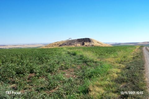
Type:
|
Mound | |||||
|
Altitude:
|
550 m | |||||
|
Diameter:
|
m- Direction: | |||||
|
|
||||||
|
Region:
|
Southeastern Anatolia | |||||
|
Province:
|
Diyarbakir | |||||
|
District:
|
Bismil | |||||
|
Village:
|
Korukçu | |||||
|
|
||||||
|
|
||||||
|
|
||||||
|
TAYEx:
|
Visited - 10/9/2001 | |||||
|
|
||||||
|
Registration State:
|
Registered For detailed registration information please refer to Turkish pages. | |||||
 |
||||||
| Location: The site is located 11 km southeast of Bismil district in Diyarbakir province. |
| Geography and Environment: Tigris River meanders towards the south after a rocky outcrop located to the west of the mound. The settlement lies on a natural hill and as a result of this it does not have the risk of flood even when the river has the highest water level. The hill overlooks the river and also can control the wide valley on the north as far as the hills located 1.5 km away. The mound measures 170x120x25 m and it is possible to research the cultural layers in wide areas. The settlement of Ziyaret Tepe is located 3 km southeast of the settlement. |
| Destruction Details: |