|
©The Archaeological Settlements of Turkey - TAY Project
|
|
|
|
|
|
Giricano |
|
|
For site maps and drawings please click on the picture...  |
For photographs please click on the photo... 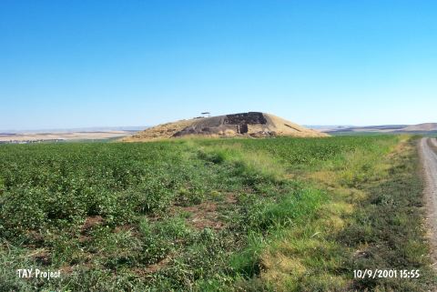 |
|
Type:
|
Mound |
|
Altitude:
|
550 m |
|
Region:
|
Southeastern Anatolia |
|
Province:
|
Diyarbakir |
|
District:
|
Bismil |
|
Village:
|
Korukçu |
|
Investigation Method:
|
Excavation |
|
Period:
|
|
|
|
|
 |
|
| Location: The site is located 11 km southeast of Bismil district in Diyarbakir province. |
| Geography and Environment: Tigris River meanders towards the south after a rocky outcrop located to the west of the mound. The settlement lies on a natural hill and as a result of this it does not have the risk of flood even when the river has the highest water level. The hill overlooks the river and also can control the wide valley on the north as far as the hills located 1.5 km away. The mound measures 170x120x25 m and it is possible to research the cultural layers in wide areas. The settlement of Ziyaret Tepe is located 3 km southeast of the settlement. |
| History: |
| Research and Excavation: A survey was conducted by G. Algaze in the previous years but the results of the research were not published. The site was excavated in 2000-2001; under the directorship of A. Schachner during the Salvage Project of the Ilisu Dam; coordinated by METU TAÇDAM. The fieldwork was associated by the Museum of Diyarbakir and supported by the German Research Fund. It takes place in the registered archaeological sites list prepared by Ministry of Culture and Tourism. |
| Stratigraphy: In the trench located on the northern slope of the hill; three periods and their different architectural layers were determined. The architectural layers lying beneath the surface were destructed by contemporary settlements; late period burials and illicit digging. This latest settlement layer; although not yielding any building plans; was assigned to the middle of 11th century BC according to the ceramics. Directly beneath this layer; there is the settlement layer of the Middle Assyrian Period with different sub-phases. Also in this area were encountered buildings dating to the first half of the 2nd millennium BC. Similar architectural features were also seen in the two trenches located on the western slope. Materials belonging to the prehistoric periods were only recovered from the test trench opened on the southern slope and the few phases determined here were assigned to the Chalcolithic Period [Schachner 2002:550-558]. |
| Small Finds: Architecture: Directly beneath the surface; was found a well-preserved building constructed using unbaked mudbrick. To the north of the trench; two parallel mudbrick walls run towards the stone paved area marked by three in situ stones on the western side of the trench. The wall on the south was probably built for terracing. The other wall; extending in the north-south direction; separates the south of the trench into two sections. The western section is paved with compressed clay and the eastern one with river pebbles. The building is bounded with a thick wall in the south. There were not any remains belonging to a wall in the southeastern corner of the building; and this has shown that the building probably had a corner here and there was an open area outside the building. Next to the entrance; a semi-circular workshop area was encountered [Schachner 2002:557;558]. Pottery: An identity of shapes and wares can be observed in the monochrome and painted ceramics. The vessels were painted directly on the clay or on a light colored base. Two types of painted decoration were determined; systematical motives with definite lines and non-systematical motives. On the coarsely painted surfaces; the brush traces have formed intersecting motives in various thickness. Similar decorations are known from Northeastern Syria and Northern Iraq. The most common vessel form is wiped in rimmed bowls with spherical bodies. Generally the rims of these bowls are decorated with bands; and in some examples the painting continues inside the vessel in two parallel lines. The majority of the organic tempered monochrome ceramics was oxidized due to firing. They are generally unwashed and the colors vary between brown; red and beige. Between the monochrome ceramics; there are a small number of reduced; smooth surfaced and sometimes polished vessels. This group can be compared with the gray Uruk ceramics (Ninive 3 ceramics) of Northern Mesopotamia and they give significant clues for the beginning of the Uruk layers. The characteristic examples of Giricano ceramics consist of thickened rimmed bowls; hole mouth bowls and jars with step shaped rims. The parallels of these vessels were encountered in Northern Mesopotamia. The pottery has a parallelism with the Gawra B materials in Northern Iraq. The gray Ninive 3 (gray Uruk) ceramics indicate that these finds can be assigned to the Gawra B or Uruk A period. Because the site has not yielded any Late Uruk material; it is also possible to date the finds to Uruk B or C. Fragments of ceramics named as "spring ware" were also found and may be belonging to the Obaid Period [Schachner 2002:558-560]. Clay: An underfired and fine mineral tempered clay bulla was found. It has the shape of a square with rounded corners. From the two corners in the bottom; it was understood that the cross-hatching impression belongs to o square shaped seal. There are diagonal lines on its preserved back side. The corners; which end with a right angle; indicate that the seal was impressed on a cornered surface [Schachner 2002:558]. Chipped Stone: Numerous obsidian tools were encountered. Ground Stone: On the pebble paved floor; numerous stone tools were found. |
| Remains: |
| Interpretation and Dating: The mound; which is located on the northern bank of the Tigris River; has yielded important information about this archaeologically less-known region. The Halaf and Obaid materials found on the surface; the Chalcolithic settlement and the layers up to the 1st millennium BC have revealed fairly long cultural series. There were no materials belonging to the Late Uruk; the periods between the end of the 3rd millennium BC and the middle of the 2nd millenium BC; and the Assyrian Period. The fact that the site has not yielded any pottery dating to a period later than the Early Iron Age shows that Giricano was not occupied after this era. According to the "spring ware" sherds; which probably belong to the end of Obeid; it can be suggested that the mound may have earlier layers. With the further researches of the Halaf and Obeid sherds; it may be possible to talk about a settlement series between the Late Neolithic and Middle Chalcolithic. The Chalcolithic finds encountered on the southern slope have shown that the development here was not different from Northern Mesopotamia. Based on these finds; for the first time it is possible to say that the Tigris Region is included in the cultural region of Northern Mesopotamia; probably beginning from Obeid; with a layer to the north of the Tur Abdin Mountains [Schachner 2002:560]. |