| ©The Archaeological Settlements of Turkey - TAY Project | ||||||
|
|
||||||
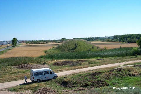
Dokuzhöyük |
||||||
|
|
||||||
| Ages | Maps | Photos | ||||
| Other/Unknown |
 |
 |
||||
|
|
||||||
|
Type:
|
Tumulus | |||||
|
Altitude:
|
49 m | |||||
|
Diameter:
|
m- Direction: | |||||
|
|
||||||
|
Region:
|
Marmara | |||||
|
Province:
|
Kirklareli | |||||
|
District:
|
Merkez | |||||
|
Village:
|
Dokuzhüyük | |||||
|
|
||||||
|
Destruction :
|
Other - Attention | |||||
|
|
||||||
|
TAYEx:
|
Visited - 12/6/2000 | |||||
|
|
||||||
|
Registration State:
|
Registered For detailed registration information please refer to Turkish pages. | |||||
 |
||||||
| Location: |
| Geography and Environment: |
| Destruction Details: The tumuli are covered with grass and the shallow ones are being planted. The skirts of the tumulus on the eastern side of the road were cut and included in the field. The ninth tumulus was not observed and is believed to be completely destructed [TAYEx 12.6.2000]. |