| ©The Archaeological Settlements of Turkey - TAY Project | ||||||
|
|
||||||
Balibagi |
||||||
|
|
||||||
| Ages | Maps | Photos | ||||
| EBA |
 |
 |
||||
|
|
||||||
|
Type:
|
Cemetery | |||||
|
Altitude:
|
750 m | |||||
|
Diameter:
|
m- Direction: | |||||
|
|
||||||
|
Region:
|
Central Anatolia | |||||
|
Province:
|
Çankiri | |||||
|
District:
|
Merkez | |||||
|
Village:
|
Balibagi | |||||
|
|
||||||
|
|
||||||
|
|
||||||
|
TAYEx:
|
Visited - 16/7/2002 | |||||
|
|
||||||
|
Registration State:
|
Registered For detailed registration information please refer to Turkish pages. | |||||
 |
||||||
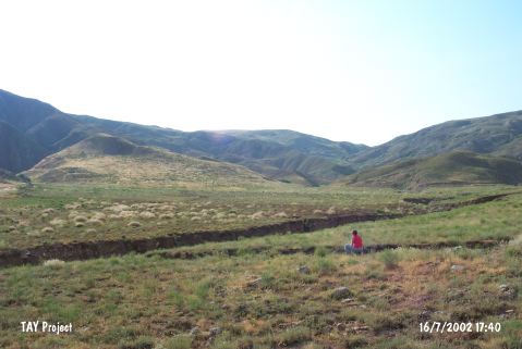
| Location: It is located at the entrance of the Sariçi Valley which is 8 km long; south of the rock-salt factory of Tekel; 5.5 km east of Balibagi Village; east of Çankiri Province. |
| Geography and Environment: The cemetery is located right across the mound of Sariiçi on the slopes next to the Magara Stream. It probably belongs to the settlement at Sariiçi Höyük. The name of the cemetery gives away that this place was used as a vineyard. The valley of Sariiçi is formed by a fault line extending in the northwest direction. The environment is rich in salt. The cemetery was disturbed by the treasure hunters before the scientific excavation. Although its borders could not be determined; the lower parts of the slope house more burials; and they decrease in number in the upper parts. |
| Destruction Details: |