| ©The Archaeological Settlements of Turkey - TAY Project | ||||||
|
|
||||||
Yortan / Gelenbe |
||||||
|
|
||||||
| Ages | Maps | Photos | ||||
| EBA |
 |
 |
||||
|
|
||||||
|
Type:
|
Cemetery | |||||
|
Altitude:
|
132 m | |||||
|
Diameter:
|
m- Direction: | |||||
|
|
||||||
|
Region:
|
Aegean | |||||
|
Province:
|
Manisa | |||||
|
District:
|
Kirkagaç | |||||
|
Village:
|
Bostanci | |||||
|
|
||||||
|
Destruction :
|
Agriculture - Highways, roads, bridges etc. - Attention | |||||
|
|
||||||
|
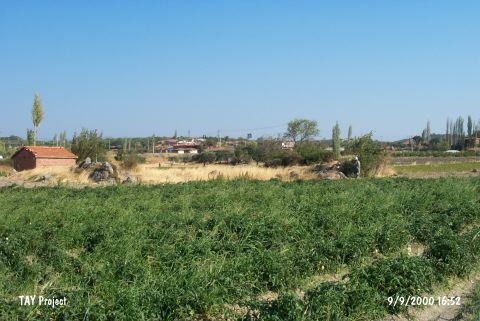
TAYEx:
|
Visited - 9/9/2000 | |||||
|
|
||||||
|
Registration State:
|
For detailed registration information please refer to Turkish pages. | |||||
 |
||||||
| Location: It lies within the territory of the Bostanli Village; south of the Gelenbe Sub-District; 16.5 km east-northeast of the Kirkagaç District of the Manisa Province and 55 km south of the Balikesir Province. To the west of it is the village of Karakurt and to the northwest Akkustepesi. |
| Geography and Environment: The area Yortan cemetery is located is a mountain near the Bakirçay Stream. Vast majority of the graves are located to south of the Gelenbe-Kirkagaç motorway. Although it is near the village of Gelenbe (sub-district at present); it is cited as Yortan in the archaeological literature. The findspot should be identified once again by the help of the local villagers. |
| Destruction Details: The cemetery is damaged due to agricultural activities and road construction [TAYEx 9.9.2000]. |