| ©The Archaeological Settlements of Turkey - TAY Project | ||||||
|
|
||||||
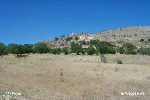
Yikilgan Siginagi |
||||||
|
|
||||||
| Ages | Maps | Photos | ||||
| Palaeolithic/Epipalaeolithic |
 |
 |
||||
|
|
||||||
|
Type:
|
Rock Shelter | |||||
|
Altitude:
|
980 m | |||||
|
Diameter:
|
m- Direction: | |||||
|
|
||||||
|
Region:
|
Eastern Anatolia | |||||
|
Province:
|
Elazig | |||||
|
District:
|
Agin | |||||
|
Village:
|
Yenipayam | |||||
|
|
||||||
|
|
||||||
|
|
||||||
|
TAYEx:
|
Visited - 16/7/2003 | |||||
|
|
||||||
|
Registration State:
|
For detailed registration information please refer to Turkish pages. | |||||
 |
||||||
| Location: This rock-shelter site is located northwest of the city of Elazig; east of the Arapkir Stream; northeast of the village of Yenipayam (also called Hastek); and 5 km west of the town of Agin. It locates 500 m south of Gedikler Mevkii. |
| Geography and Environment: The area between Agin and Elazig must have been suitable for Palaeolithic habitation and hunting because the region is rich in natural resources and because the Yikilgan rock-shelter provided a protected camping area. Yikilgan; a large rock-shelter whose front terrace has been blocked by stones; is fit to be used in the winter because the entrance faces away from the northern winds. Although it is reported that the rock-shelter is large; its dimensions have not been given. |
| Destruction Details: |