| ©The Archaeological Settlements of Turkey - TAY Project | ||||||
|
|
||||||
Yazir Höyük |
||||||
|
|
||||||
| Ages | Maps | Photos | ||||
| Chalcolithic EBA |
 |
 |
||||
|
|
||||||
|
Type:
|
Mound | |||||
|
Altitude:
|
945 m | |||||
|
Diameter:
|
88 m- Direction: ESE-WNW | |||||
|
|
||||||
|
Region:
|
Central Anatolia | |||||
|
Province:
|
Eskisehir | |||||
|
District:
|
Sivrihisar | |||||
|
Village:
|
Dutlu | |||||
|
|
||||||
|
Destruction :
|
Agriculture | |||||
|
|
||||||
|
TAYEx:
|
Visited - 1/7/2002 | |||||
|
|
||||||
|
Registration State:
|
For detailed registration information please refer to Turkish pages. | |||||
 |
||||||
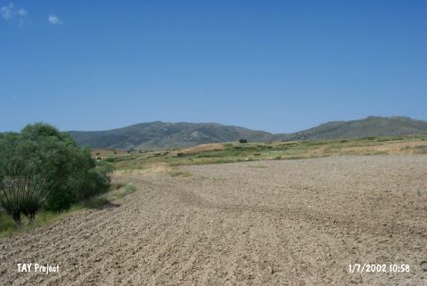
| Location: The mound lies in Örenbaglari Mevkii; east of Dutlu village and 3.6 km southwest of Çardaközü village of Günyüzü Town; east of Sivrihisar District of Eskisehir Province. |
| Geography and Environment: Yazir Stream that joins Çardak Özü in the north; flows by the site. The ovoid mound; surrounded by fertile fields; lies on a natural elevation in this valley; approximately 20 m higher than water level. It covers an area no more than 95 m in diameter depending on distribution of pottery and the cultural deposit is 9 m high [Temizer 1960:157]. In 1955; a great fissure was dug in the center of the mound by illicit diggers. |
| Destruction Details: The mound has completely lost its shape as a result of agricultural activities [TAYEx 1.7.2002]. |