|
©The Archaeological Settlements of Turkey - TAY Project
|
|
|
|
|
|
Yazir Höyük |
|
|
For site maps and drawings please click on the picture...  |
For photographs please click on the photo... 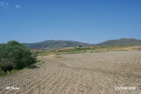 |
|
Type:
|
Mound |
|
Altitude:
|
945 m |
|
Region:
|
Central Anatolia |
|
Province:
|
Eskisehir |
|
District:
|
Sivrihisar |
|
Village:
|
Dutlu |
|
Investigation Method:
|
Excavation |
|
Period:
|
|
|
|
|
 |
|
| It lies about 18 km southeast of Sivrihisar; 2-3 km northeast of Yazir Village of Sivrihisar District; southeast of Eskisehir Province. It is located 6 km south of the Ankara-Sivrihisar motorway. The site called Ören Baglari has a cultural deposit of ca. 9 m thick. The diameter of the oval mound is 95 m. The Yazirdere Stream joining the Çardaközü Stream flows nearby. The section caused by the treasure hunters who bisected the mound was investigated by R. Temizer. Pottery of the Chalcolithic Age was collected from this deposit of 8 m thick. EBA sherds came also out of the slopes and the top hill. Further investigation is necessary for the EBA finds. |
| Location: The mound lies in Örenbaglari Mevkii; east of Dutlu village and 3.6 km southwest of Çardaközü village of Günyüzü Town; east of Sivrihisar District of Eskisehir Province. |
| Geography and Environment: Yazir Stream that joins Çardak Özü in the north; flows by the site. The ovoid mound; surrounded by fertile fields; lies on a natural elevation in this valley; approximately 20 m higher than water level. It covers an area no more than 95 m in diameter depending on distribution of pottery and the cultural deposit is 9 m high [Temizer 1960:157]. In 1955; a great fissure was dug in the center of the mound by illicit diggers. |
| History: |
| Research and Excavation: |
| Stratigraphy: |
| Small Finds: |
| Remains: |
| Interpretation and Dating: |