| ©The Archaeological Settlements of Turkey - TAY Project | ||||||
|
|
||||||
Yassi Höyük |
||||||
|
|
||||||
| Ages | Maps | Photos | ||||
| EBA IA |
 |
 |
||||
|
|
||||||
|
Type:
|
Mound | |||||
|
Altitude:
|
1145 m | |||||
|
Diameter:
|
m- Direction: | |||||
|
|
||||||
|
Region:
|
Central Anatolia | |||||
|
Province:
|
Kirsehir | |||||
|
District:
|
Merkez | |||||
|
Village:
|
Karahidir | |||||
|
|
||||||
|
Destruction :
|
Agriculture - Highways, roads, bridges etc. | |||||
|
|
||||||
|
TAYEx:
|
Visited - 30/7/2002 | |||||
|
|
||||||
|
Registration State:
|
Registered For detailed registration information please refer to Turkish pages. | |||||
 |
||||||
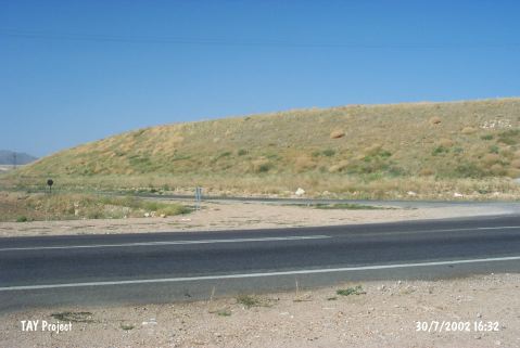
| Location: It lies northeast of the road at the Karahidir junction on Kaman-Kirsehir motorway; south of Karahidir Village; about 20 km northwest of Kirsehir Province. It is located about 25 km east of Kaman Kalehöyük. |
| Geography and Environment: It was also investigated by the Kaman Kalehöyük team. It measures 12.5 m in height and 500 m in diameter. The traces of the pits are visible on the eastern foothill. The villagers remove the soil from this part. The northern part of the flat mound ends in a soft inclination. As a result of the measurements taken during the beginning of the excavations in 2009 the mound is measured as 635 m in east-west direction and 500 m in north-south direction and 13 m in height [Omura 2011:361]. |
| Destruction Details: There are planted fields on the mound and its southern skirt is cut by the motorway [TAYEx 30.7.2002]. |