| ©The Archaeological Settlements of Turkey - TAY Project | ||||||
|
|
||||||
Ürgüp Kara-in |
||||||
|
|
||||||
| Ages | Maps | Photos | ||||
| Palaeolithic/Epipalaeolithic |
 |
 |
||||
|
|
||||||
|
Type:
|
Single Findspot | |||||
|
Altitude:
|
1305 m | |||||
|
Diameter:
|
m- Direction: | |||||
|
|
||||||
|
Region:
|
Central Anatolia | |||||
|
Province:
|
Nevsehir | |||||
|
District:
|
Ürgüp | |||||
|
Village:
|
Karain | |||||
|
|
||||||
|
|
||||||
|
|
||||||
|
TAYEx:
|
Visited - 26/7/2002 | |||||
|
|
||||||
|
Registration State:
|
For detailed registration information please refer to Turkish pages. | |||||
 |
||||||
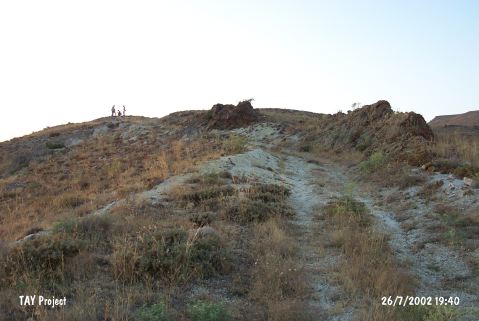
| Location: This cave-site is east of the province of Nevsehir and southeast of the town of Ürgüp. Artifacts were found on the terrace northeast of the village of Karain and on the flanks of the valley by the railroad tracks heading to the Yavas Train Station. In order to avoid confusion with the Karain Cave in Antalya; this site has been called Ürgüp Kara-in. |
| Geography and Environment: It has been determined that there are a total of five terraces in this area. Very close to the village is the Çakmaklik flintstone quarry. It is also reported that there are several caves in the area; which overlook a stream whose name is not mentioned (the Karagöz Stream?). |
| Destruction Details: |