|
©The Archaeological Settlements of Turkey - TAY Project
|
|
|
|
|
|
Ürgüp Kara-in |
|
|
For site maps and drawings please click on the picture...  |
For photographs please click on the photo... 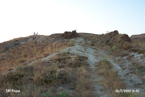 |
|
Type:
|
Single Findspot |
|
Altitude:
|
1305 m |
|
Region:
|
Central Anatolia |
|
Province:
|
Nevsehir |
|
District:
|
Ürgüp |
|
Village:
|
Karain |
|
Investigation Method:
|
Survey |
|
Period:
|
OP |
|
|
|
 |
|
| Location: This cave-site is east of the province of Nevsehir and southeast of the town of Ürgüp. Artifacts were found on the terrace northeast of the village of Karain and on the flanks of the valley by the railroad tracks heading to the Yavas Train Station. In order to avoid confusion with the Karain Cave in Antalya; this site has been called Ürgüp Kara-in. |
| Geography and Environment: It has been determined that there are a total of five terraces in this area. Very close to the village is the Çakmaklik flintstone quarry. It is also reported that there are several caves in the area; which overlook a stream whose name is not mentioned (the Karagöz Stream?). |
| History: |
| Research and Excavation: The site was discovered in 1946 by a group of faculty members including Afet Inan; I.K. Kökten; Enver Bostanci and a team of student researchers from the Ankara University DTCF Department of Archaeology; Subdepartment of Prehistory. The Kara-in Region yielded chipped stone tools and pottery. Some obsidian microliths were found in a riverbed nearby. |
| Stratigraphy: |
| Small Finds: Inan reports that two of the Moustérien finds he assigns to the Middle Palaeolithic deserve special mention [Inan 1947:fig.1]. Kökten; Kansu; Bostanci and Senyürek; who have made general inventories of Palaeolithic sites in Turkey; have excluded this site. The dating of these tools and their drawings should be viewed with scepticism until further research is conducted. |
| Remains: |
| Interpretation and Dating: |