| ©The Archaeological Settlements of Turkey - TAY Project | ||||||
|
|
||||||
Tirmil Tepe |
||||||
|
|
||||||
| Ages | Maps | Photos | ||||
| Neolithic EBA IA |
 |
 |
||||
|
|
||||||
|
Type:
|
Mound | |||||
|
Altitude:
|
140 m | |||||
|
Diameter:
|
m- Direction: | |||||
|
|
||||||
|
Region:
|
Mediterranean | |||||
|
Province:
|
Mersin | |||||
|
District:
|
Merkez | |||||
|
Village:
|
Çilek | |||||
|
|
||||||
|
Destruction :
|
Contemporary Settlements | |||||
|
|
||||||
|
TAYEx:
|
Visited - 14/7/2001 | |||||
|
|
||||||
|
Registration State:
|
For detailed registration information please refer to Turkish pages. | |||||
 |
||||||
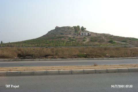
| Location: The site lies in Çilek Quarter; northeast of the city of Mersin; and north of the Mersin-Tarsus highway and railroad tracks. The mound can be found on a 1:200;000 map. |
| Geography and Environment: The mound that is also known as Turmil or Termil is 12 m high and has a 30 m diameter. The top part of the mound is flat. Modern buildings have been built on the slopes of the mound. There are stone ruins of a late period structure on the top of the mound. Since the site lies on a trade route; the ruins are believed to have been a stop for travelers. This site is believed to be where the Kale-i Hebelleç castle; which lies between the Mersin and Tarsus; is located. |
| Destruction Details: There is a house on southern slope of the mound which has been registered and encircled with wire fence [TAYEx 14.7.2001]. |