| ©The Archaeological Settlements of Turkey - TAY Project | ||||||
|
|
||||||
Mezraa Teleilat |
||||||
|
|
||||||
| Ages | Maps | Photos | ||||
| Neolithic IA 14C |
 |
 |
||||
|
|
||||||
|
Type:
|
Mound | |||||
|
Altitude:
|
500 m | |||||
|
Diameter:
|
m- Direction: | |||||
|
|
||||||
|
Region:
|
Southeastern Anatolia | |||||
|
Province:
|
Sanliurfa | |||||
|
District:
|
Birecik | |||||
|
Village:
|
Mezraa | |||||
|
|
||||||
|
Destruction :
|
Agriculture - Attention | |||||
|
|
||||||
|
TAYEx:
|
Visited - 14/8/2001 | |||||
|
|
||||||
|
Registration State:
|
Registered For detailed registration information please refer to Turkish pages. | |||||
 |
||||||
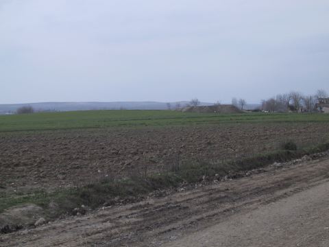
| Location: The site lies northwest of the city of Sanliurfa; 5 km south of the town of Birecik; immediately to the west and partially beneath the modern village of Mezraa. |
| Geography and Environment: The site lies very close to the large meander of the Euphrates; on the first flood terrace east of the Euphrates River. There is an old canal west of the site. The site is an oval mound; 450 m in north south direction and 160 m in east west direction. It is approximately 4 m high. It has been reported that the total area of the site is 7 hectares. A 160x160 m area in the northern part of the mound was destroyed by a bulldozer when an orchard was planted. The orchard construction created a long 1.5 m high cross-sectional profile of the mound. Parts of the mound are cultivated. |
| Destruction Details: |