| ©The Archaeological Settlements of Turkey - TAY Project | ||||||
|
|
||||||
Tekkeköy - Findicak |
||||||
|
|
||||||
| Ages | Maps | Photos | ||||
| Palaeolithic/Epipalaeolithic |
 |
 |
||||
|
|
||||||
|
Type:
|
Rock Shelter | |||||
|
Altitude:
|
55 m | |||||
|
Diameter:
|
m- Direction: | |||||
|
|
||||||
|
Region:
|
Black Sea | |||||
|
Province:
|
Samsun | |||||
|
District:
|
Merkez | |||||
|
Village:
|
Tekkeköy | |||||
|
|
||||||
|
Destruction :
|
Agriculture | |||||
|
|
||||||
|
TAYEx:
|
Visited - 6/9/2003 | |||||
|
|
||||||
|
Registration State:
|
For detailed registration information please refer to Turkish pages. | |||||
 |
||||||
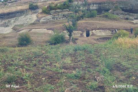
| Location: This rock-shelter is located approximately 14 km southeast of the city of Samsun; south of the village of Tekeköy; which is west of the Çarsamba Plain. The site lies in the valley at the confluence of the Findincak and Çinarlik streams; which spring from Mount Ayitepesi and Karabücük. The site lies partially on the plain and partially on the flanks of the hills on both sides of the valley in the village of Tekkeköy (or Tekeköy); now a district of the Samsun city. |
| Geography and Environment: Immediately south of the village beyond the forested mountains is a wide valley with eroded rock outcrops and fields. Fresh water springs are abundant in the area. The entrance of the rock-shelter; which can be seen from the Samsun-Çarsamba railroad; faces the Black Sea. Research revealed that there are 30 small and 6 large rock shelters and 2 caves in the area. Of the many rock-shelters; one; a few meters above the river bed; yielded surface finds by its entrance. This rock-shelter was excavated and labeled Tekeköy "A". Since no other descriptive information has been provided; it is difficult to know the exact location of this rock shelter and its relationship to the other natural cavities. |
| Destruction Details: The settlement has been severely damaged due to cultivation and contemporary settlements. There is an electricity pole on it [TAYEx 6.9.2003]. |