|
©The Archaeological Settlements of Turkey - TAY Project
|
|
|
|
|
|
Tekkeköy - Findicak |
|
|
For site maps and drawings please click on the picture...  |
For photographs please click on the photo... 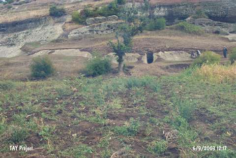 |
|
Type:
|
Rock Shelter |
|
Altitude:
|
55 m |
|
Region:
|
Black Sea |
|
Province:
|
Samsun |
|
District:
|
Merkez |
|
Village:
|
Tekkeköy |
|
Investigation Method:
|
Excavation |
|
Period:
|
EP AP OP |
|
|
|
 |
|
| Location: This rock-shelter is located approximately 14 km southeast of the city of Samsun; south of the village of Tekeköy; which is west of the Çarsamba Plain. The site lies in the valley at the confluence of the Findincak and Çinarlik streams; which spring from Mount Ayitepesi and Karabücük. The site lies partially on the plain and partially on the flanks of the hills on both sides of the valley in the village of Tekkeköy (or Tekeköy); now a district of the Samsun city. |
| Geography and Environment: Immediately south of the village beyond the forested mountains is a wide valley with eroded rock outcrops and fields. Fresh water springs are abundant in the area. The entrance of the rock-shelter; which can be seen from the Samsun-Çarsamba railroad; faces the Black Sea. Research revealed that there are 30 small and 6 large rock shelters and 2 caves in the area. Of the many rock-shelters; one; a few meters above the river bed; yielded surface finds by its entrance. This rock-shelter was excavated and labeled Tekeköy "A". Since no other descriptive information has been provided; it is difficult to know the exact location of this rock shelter and its relationship to the other natural cavities. |
| History: |
| Research and Excavation: Excavation of Tekeköy "A" was conducted in 1940 under the direction of Nimet and Tahsin Özgüç and Kiliç Kökten's supervision [Kökten et al.1945:382-383]. The site report published by Kökten does not correlate with Kansu's; who visited the site in 1941. While Kökten reports that the 320 cm that was excavated consisted of 10 layers; Kansu; who studied the trench profiles the following season; notes only 5. According to Kökten; Layer I dates to a ceramic period (?) and is 64 cm deep while the next two yellowish sandy layers; II and III; are 96 cm and 38 cm deep respectively. These layers both lack pottery and are rich in chipped stone tools and faunal remains. Beneath this; Kökten reports; are 6 gravelly sand layers without archaeological remains totaling 122 cm. Kansu; on the other hand; reports that there are a total of 5 layers; the first of which is a 38 cm thick sandy and pebbly layer with organic remains; followed by a 96 cm thick second layer which includes microlith chipped stone tools and animal bones. A third; 68 cm deep; silty layer contains fewer microlith tools. The fourth layer; yellowish sand; overlies Layer V which is composed of gravelly sandy soil [Kansu 1944:677-682]. In his survey of the neighboring caves and rock-shelters; in 1940; Kökten found many chipped stone tools on the valley terraces as well as in the rock-shelters [Kökten 1941:124; Kökten 1944a:470]. Yalçinkaya identifies one tool; (a biface handaxe) found approximately 12 km southeast of the city of Samsun; along the Samsun-Çarsamba railroad tracks and calls it the Tekeköy Find [Yalçinkaya 1985:429]. |
| Stratigraphy: |
| Small Finds: It is reported that retouched microlith tools are abundant in Layers II and III of rock-shelter "A"; as defined both by Kansu and Kökten. Kansu places the tools; which resemble northwestern European microlith industries; in three categories: micro-burins; micro-scrapers; and other microlith tools [Kansu 1944:673; 677; fig 2-4]. In his report of the Beldibi and Belbasi microliths; Bostanci mentions that the Tekeköy finds are not real microliths; and believes that only two tools; a burin made on a blade and an end scraper made on a flake; can be considered Mesolithic and assigns all the rest of the tools are Upper Palaeolithic [Bostanci 1967b:58-59]. Although the excavations yielded a large number of animal bones and teeth including buffalo and horse; no faunal research has been conducted. Kökten reports that the tools are made from a variety of materials; while the smaller of the two Moustérien tools he found on the valley terrace is a diorite scraper; the larger is a point made from basalt. The biface found by the railroad tracks; on the other hand; is Acheuléen in character and is made of andesite. This biface must have been brought to this location from the mountains by natural agents. |
| Remains: |
| Interpretation and Dating: |