| ©The Archaeological Settlements of Turkey - TAY Project | ||||||
|
|
||||||
Taskun Mevkii |
||||||
|
|
||||||
| Ages | Maps | Photos | ||||
| EBA |
 |
 |
||||
|
|
||||||
|
Type:
|
Mound | |||||
|
Altitude:
|
845 m | |||||
|
Diameter:
|
m- Direction: | |||||
|
|
||||||
|
Region:
|
Eastern Anatolia | |||||
|
Province:
|
Elazig | |||||
|
District:
|
Merkez | |||||
|
Village:
|
Muratcik | |||||
|
|
||||||
|
Destruction :
|
Dams - Contemporary Settlements - Attention | |||||
|
|
||||||
|
TAYEx:
|
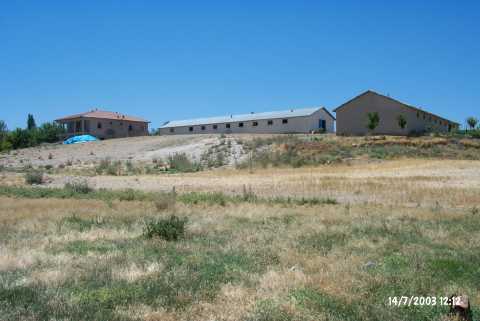
Visited - 14/7/2003 | |||||
|
|
||||||
|
Registration State:
|
For detailed registration information please refer to Turkish pages. | |||||
 |
||||||
| Location: It lies 8.5 km west of the Balibey Sub-District; 5 km southeast of Asvan (submerged at present); and 30 km northwest of the Elazig Province as the crow flies. The motorway running from Elazig to Asvan passes by the settlement. It has not been influenced by the Keban Dam even tough the waters of the lake come near. Only 1 km far from Taskun Kale; it is sometimes evaluated together within the same culture in the publications [Korfmann et al. 1994:200]. It is coded under N 52 / 1. |
| Geography and Environment: It is a round; low and flat mound; 110 m in diameter [Sagona 1984b:5] located on the western bank of a seasonal stream in the Valley of Kuruçay. It is 5.6 m high on the northern part while only 3.2 m high on the southern part. To the southwest lies a small fresh water spring. S. Helms propose that the swap area around the mound met the water requirements of the inhabitants [Helms 1972:51]. |
| Destruction Details: The mound is completely under the contemporary settlement also the dam reservoir influences the skirts [TAYEx 14.7.2003]. |