| ©The Archaeological Settlements of Turkey - TAY Project | ||||||
|
|
||||||
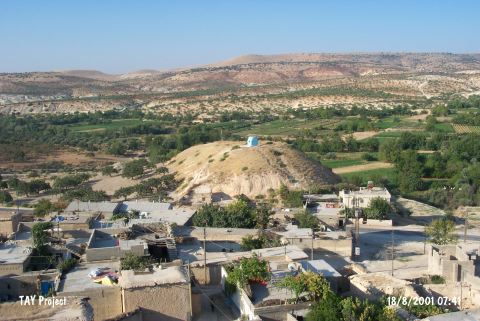
Sehzade Höyük / Turlu |
||||||
|
|
||||||
| Ages | Maps | Photos | ||||
| Palaeolithic/Epipalaeolithic Neolithic Chalcolithic 14C |
 |
 |
||||
|
|
||||||
|
Type:
|
Mound | |||||
|
Altitude:
|
700 m | |||||
|
Diameter:
|
m- Direction: | |||||
|
|
||||||
|
Region:
|
Southeastern Anatolia | |||||
|
Province:
|
Gaziantep | |||||
|
District:
|
Nizip | |||||
|
Village:
|
Turlu | |||||
|
|
||||||
|
Destruction :
|
Contemporary Settlements | |||||
|
|
||||||
|
TAYEx:
|
Visited - 18/8/2001 | |||||
|
|
||||||
|
Registration State:
|
Registered For detailed registration information please refer to Turkish pages. | |||||
 |
||||||
| Location: This site lies 48 km east of the city of Gaziantep; north of the town of Nizip; near the Turlu District; along the Nizip highway. |
| Geography and Environment: The site; which in many archaeological publications is described as a Halaf site; lies in a narrow valley. |
| Destruction Details: The northern skirt of the mound was cut and two houses built there. At the top of the mound there is grave and this area is leveled a bit [TAYEx 18.8.2001]. |