| ©The Archaeological Settlements of Turkey - TAY Project | ||||||
|
|
||||||
Sarkli Magara |
||||||
|
|
||||||
| Ages | Maps | Photos | ||||
| Palaeolithic/Epipalaeolithic |
 |
 |
||||
|
|
||||||
|
Type:
|
Cave | |||||
|
Altitude:
|
890 m | |||||
|
Diameter:
|
m- Direction: | |||||
|
|
||||||
|
Region:
|
Southeastern Anatolia | |||||
|
Province:
|
Gaziantep | |||||
|
District:
|
Merkez | |||||
|
Village:
|
Dülük | |||||
|
|
||||||
|
|
||||||
|
|
||||||
|
TAYEx:
|
Not visited - | |||||
|
|
||||||
|
Registration State:
|
For detailed registration information please refer to Turkish pages. | |||||
 |
||||||
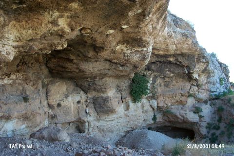
| Location: This cave site lies 10 km north of the city of Gaziantep; in the valley at the foot of Keber Tepe; near the Dülük train station (See the site of Dülük for more information on open air sites in the area). |
| Geography and Environment: The cave; which is locally referred to as the Keber Cave; is carved out in Helvetian limestone. Because the researcher who discovered this cave called the cave Sarkli Magara; this name has remained in archaeological literature. It has a spacious interior; 17 m deep; 13 m high and 84 m wide. The mussel shells found during the excavations indicate that there must have been a nearby lake in the Epipalaeolithic. |
| Destruction Details: |