|
©The Archaeological Settlements of Turkey - TAY Project
|
|
|
|
|
|
Sarkli Magara |
|
|
For site maps and drawings please click on the picture...  |
For photographs please click on the photo... 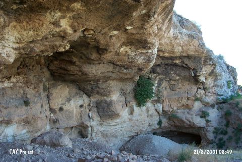 |
|
Type:
|
Cave |
|
Altitude:
|
890 m |
|
Region:
|
Southeastern Anatolia |
|
Province:
|
Gaziantep |
|
District:
|
Merkez |
|
Village:
|
Dülük |
|
Investigation Method:
|
Excavation |
|
Period:
|
EP ÜP |
|
|
|
 |
|
| Location: This cave site lies 10 km north of the city of Gaziantep; in the valley at the foot of Keber Tepe; near the Dülük train station (See the site of Dülük for more information on open air sites in the area). |
| Geography and Environment: The cave; which is locally referred to as the Keber Cave; is carved out in Helvetian limestone. Because the researcher who discovered this cave called the cave Sarkli Magara; this name has remained in archaeological literature. It has a spacious interior; 17 m deep; 13 m high and 84 m wide. The mussel shells found during the excavations indicate that there must have been a nearby lake in the Epipalaeolithic. |
| History: |
| Research and Excavation: The cave-site in which excavations took place in 1971 and 1982 was discovered by Enver Yasar Bostanci in 1971. While the only purpose of the two meter deep test trench of the 1971 excavations was to determine whether there was a Palaeolithic habitation in the cave; the 1982 excavations were much more comprehensive. In 1982 two trenches; one 3x17 m to the right (?) of the entrance; and another 1.5x6 m trench at the front of the cave were opened and excavated to a depth of 9 m. The stratigraphy of the 1982 excavation revealed that the top 12 layers; collectively 7.14 meters thick; were assigned to the Bronze Age. Beneath this was 1.86 cm thick thirteenth layer which dated to the Neolithic; Epipalaeolithic and Upper Palaeolithic. No information is provided on the Neolithic component of this layer. This site is especially important because the wall paintings here resemble those on the Mediterranean coast which were initially drawn and then painted in with black paint. Bostanci believes that the rows of lines painted on the wall probably represent a counting method [Bostanci 1984:fig.1]. |
| Stratigraphy: |
| Small Finds: The Epipalaeolithic layers of the 1971 and 1982 excavations yielded several triangular; trapezoidal and crescent-shaped micro-burins and small triangular burins on flakes. Layers dating to this period yielded ironoxide nodules probably used to make paints. Other finds from these layers include side scrapers; rounded scrapers; triangular convex scrapers; end scrapers; and crescent-shaped short; long and thin scrapers (uncharacteristic of the Epipalaeolithic) [Bostanci 1984:fig.4]. Bostanci makes special reference to a flake he suggests might have been used for surgery. He differentiates this industry; where flaking is preferred over blade removal; from the Mediterranean coastal techniques by referring to it as the "Sarklian Industry" [Bostanci 1984:53]. Faunal remains from the Epipalaeolithic layers; indicative of local subsistence patterns include wild pig; wolf; gazelle; wild goat; red deer; sheep and horse. Fragments of an Epipalaeolithic human cranium were found beyond the excavation area. The Upper Palaeolithic chipped stone tools; on the other hand; have Magdalenien characteristics. Because Bostanci felt that the characteristics of the artifacts dating to this period were distinctly different from the Upper Palaeolithic techniques in the Adiyaman province; he preferred to call this industry the "Dülüan" industry; after the village of Dülük. Large blades and stemmed points are the most common characteristics of this industry. The researcher does not describe other characteristics in detail probably because the 1982 excavations did not get beyond the Epipalaeolithic and perhaps some of the Upper Palaeolithic levels thus limiting the sample size. Bostanci hopes further excavations will lead to the discovery of Protosolutreén levels. |
| Remains: |
| Interpretation and Dating: |