| ©The Archaeological Settlements of Turkey - TAY Project | ||||||
|
|
||||||
Avla Dag |
||||||
|
|
||||||
| Ages | Maps | Photos | ||||
| Palaeolithic/Epipalaeolithic Neolithic EBA |
 |
 |
||||
|
|
||||||
|
Type:
|
Flat Settlement | |||||
|
Altitude:
|
1325 m | |||||
|
Diameter:
|
m- Direction: | |||||
|
|
||||||
|
Region:
|
Central Anatolia | |||||
|
Province:
|
Nevsehir | |||||
|
District:
|
Ürgüp | |||||
|
Village:
|
Mustafapasa | |||||
|
|
||||||
|
Destruction :
|
Natural causes | |||||
|
|
||||||
|
TAYEx:
|
Visited - 27/7/2002 | |||||
|
|
||||||
|
Registration State:
|
For detailed registration information please refer to Turkish pages. | |||||
 |
||||||
| Location: This site lies east of the city of Nevsehir; 8 km south-southeast of the town of Ürgüp; 2 km northwest of the village of Karlik. It is possible to reach the site via the Nevsehir-Ürgüp-Mustafapasa highway. |
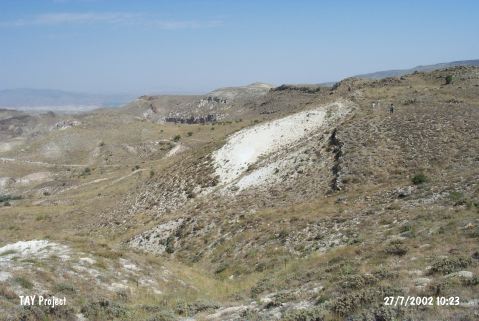
| Geography and Environment: The conical shape of volcanic Mount Avladag can be seen from the Aksaray Region. It has been noted that the finds were collected from a terrace 300 m below the highest terraces of Mount Avladag; east of the Damsa Stream Valley. The terrace which yielded the artifacts has been schematically represented in the site publication [Todd-Pasquare 1965:fig.1]. |
| Destruction Details: The site is being damaged due to erosion [TAYEx 27.7.2002]. |