|
©The Archaeological Settlements of Turkey - TAY Project
|
|
|
|
|
|
Avla Dag |
|
|
For site maps and drawings please click on the picture...  |
For photographs please click on the photo... 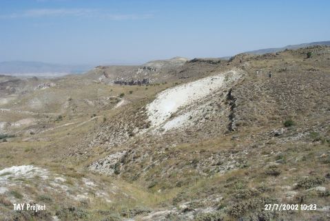 |
|
Type:
|
Flat Settlement |
|
Altitude:
|
1325 m |
|
Region:
|
Central Anatolia |
|
Province:
|
Nevsehir |
|
District:
|
Ürgüp |
|
Village:
|
Mustafapasa |
|
Investigation Method:
|
Survey |
|
Period:
|
Ceramic |
|
|
|
 |
|
| Location: This site lies east of the city of Nevsehir; 8 km south-southeast of the town of Ürgüp; 2 km northwest of the village of Karlik. It is possible to reach the site via the Nevsehir-Ürgüp-Mustafapasa highway. |
| Geography and Environment: The conical shape of volcanic Mount Avladag can be seen from the Aksaray Region. It has been noted that the finds were collected from a terrace 300 m below the highest terraces of Mount Avladag; east of the Damsa Stream Valley. The terrace which yielded the artifacts has been schematically represented in the site publication [Todd-Pasquare 1965:fig.1]. |
| History: |
| Research and Excavation: Artifacts were collected from this site by geologist G. Pasquare in 1963-64 during his MTA geological survey of Central Anatolia. Todd who also surveyed the area in the same year published Pasquare's findings [Todd-Pasquare 1965:95-112]. (For information on the Palaeolithic at Avladag see Harmankaya-Tanindi 1996:Avla Dag). |
| Stratigraphy: The finds from the site include not only Neolithic material but also artifacts dating to the Palaeolithic and the Early Bronze Age II-III. The site also yielded some dark burnished ware which could not be dated. The terrace lies 150 m above the Damsa Stream Valley and 300 m beneath the highest point on Avladag; between 1;260 and 1;300 m in altitude [Todd-Pasquare 1965:95]. |
| Small Finds: Pottery: The lower terrace yielded handmade; sand tempered; black and brown burnished ware which has been assigned to the Neolithic. Chipped Stone: Many of the 1;021 chipped stone tools recovered by Todd and Pasquare were of obsidian while a few were knapped from coarse flint and basalt. No information has been provided on the find densities of these artifacts. Most of the tools are flakes and blades although a few micro-tools were also recovered. The fact that some of the blades were used as sickles as well as the fact that pressure-flaked points and spear-heads were found; allows the site to be assigned to the Neolithic period. |
| Remains: |
| Interpretation and Dating: At the site of Avladag no absolute dating was done. The artifacts found number around 1;000. Esin believes that the dating of the site is difficult because of the abundance of tools knapped in the Levallois technique in the Upper Palaeolithic Period [Esin 1981:8]. Therefore; it is also possible that the ceramics; which may or may not have been found together with the chipped stone tools; date to a later period than expected. The inhabitants of Avladag; living in an area suitable for hunting; were probably hunter gatherers. It is believed that the area was used as a camp-site both by Aceramic Neolithic hunter gatherers as well as in the Late Ceramic Neolithic. The extent of the site has not been determined because the survey of the area was not systematic. No architectural remains have been reported. |