| ©The Archaeological Settlements of Turkey - TAY Project | ||||||
|
|
||||||
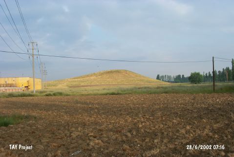
Asagi Sögütönü |
||||||
|
|
||||||
| Ages | Maps | Photos | ||||
| EBA IA |
 |
 |
||||
|
|
||||||
|
Type:
|
Mound | |||||
|
Altitude:
|
830 m | |||||
|
Diameter:
|
157 m- Direction: NW-SE | |||||
|
|
||||||
|
Region:
|
Central Anatolia | |||||
|
Province:
|
Eskisehir | |||||
|
District:
|
Merkez | |||||
|
Village:
|
Asagi Sögütönü | |||||
|
|
||||||
|
Destruction :
|
Illicit Digging | |||||
|
|
||||||
|
TAYEx:
|
Visited - 28/6/2002 | |||||
|
|
||||||
|
Registration State:
|
Registered For detailed registration information please refer to Turkish pages. | |||||
 |
||||||
| Location: |
| Geography and Environment: |
| Destruction Details: There are three pits on the mound made by illicit diggers and its northwest; northeast and west skirts are cut. There is an electricity pole on its southeast slope [TAYEx 28.6.2002]. |