| ©The Archaeological Settlements of Turkey - TAY Project | ||||||
|
|
||||||
Orman Fidanligi |
||||||
|
|
||||||
| Ages | Maps | Photos | ||||
| Chalcolithic |
 |
 |
||||
|
|
||||||
|
Type:
|
Flat Settlement | |||||
|
Altitude:
|
820 m | |||||
|
Diameter:
|
m- Direction: | |||||
|
|
||||||
|
Region:
|
Central Anatolia | |||||
|
Province:
|
Eskisehir | |||||
|
District:
|
Merkez | |||||
|
Village:
|
Merkez | |||||
|
|
||||||
|
Destruction :
|
Mines/Quarries - Highways, roads, bridges etc. - Attention | |||||
|
|
||||||
|
TAYEx:
|
Visited - 29/6/2002 | |||||
|
|
||||||
|
Registration State:
|
For detailed registration information please refer to Turkish pages. | |||||
 |
||||||
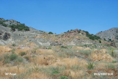
| Location: The site is located 5-6 km southwest of Eskisehir; within the borders of Orman Fidanligi of Eskisehir Municipality. It is quite easy to get to the site since the Eskisehir-Kütahya highway passes between the site and the 140 m far Porsuk Stream. |
| Geography and Environment: The site lies at the western and southern skirts of a steep rocky elevation on the southern slope of the low hills named Karabayirlar. Karabayirlar are the northern borders of the valley of Yukari Porsuk Stream; therefore the site oversees the valley. The cultural deposit is locked by the eroded debris of the slopes and this sterile deposit is 8-10 m thick at the south of the site. It lies close to the point where the valley meets Eskisehir Plain and is surrounded by quite fertile plains. It is not reported whether or not are there any natural water springs around the site; but the stream should have flown very close to the site during the period it was settled. |
| Destruction Details: Rubble and construction remains dumped to the site. Soil has been taken from west-southwest part of the mound [TAYEx 29.6.2002]. |