| ©The Archaeological Settlements of Turkey - TAY Project | ||||||
|
|
||||||
Menekse Çatagi |
||||||
|
|
||||||
| Ages | Maps | Photos | ||||
| Chalcolithic EBA IA |
 |
 |
||||
|
|
||||||
|
Type:
|
Mound | |||||
|
Altitude:
|
7 m | |||||
|
Diameter:
|
m- Direction: | |||||
|
|
||||||
|
Region:
|
Marmara | |||||
|
Province:
|
Tekirdag | |||||
|
District:
|
Merkez | |||||
|
Village:
|
Gazioglu | |||||
|
|
||||||
|
Destruction :
|
Agriculture | |||||
|
|
||||||
|
TAYEx:
|
Visited - 27/5/2000 | |||||
|
|
||||||
|
Registration State:
|
Registered For detailed registration information please refer to Turkish pages. | |||||
 |
||||||
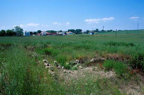
| Location: It lies on both banks of the Menekse Stream on rocky terraces; on the shore of the Marmara Sea; 50 m south of the Tekirdag-Istanbul motorway; 12 km east of the Tekirdag Province. |
| Geography and Environment: Flat hills lying on both banks of the Menekse Stream are named as West and East hills. In the section where the eastern and western mounds are located; shores of Marmara constitute a seaside cliff; 10 m high; formed by sandstone rocks. Beneath the cliff lie small beaches. There are two fresh water springs near the mound. The western mound measures 100x60x3 m while the eastern mound has two elevations; one measuring 2 m in height and 60 m in diameter east to the stream; and the other one being a flat elevation situated 200 m east of the stream. A portion of the eastern settlement has been truncated by the Marmara Sea. |
| Destruction Details: The settlement is surrounded by fields and a large part of the mound is being used for agriculture [TAYEx 27.5.2000]. |